
Haz una donación
Mapa topográfico Stanstead St Margarets
Haga clic en el mapa para ver la altitud.
Haz una donación
Acerca de este mapa
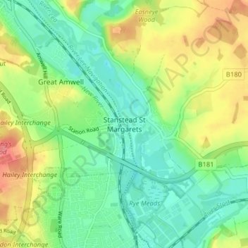
Nombre: Mapa topográfico Stanstead St Margarets, altitud, relieve.
Altitud media: 48 m
Altitud mínima: 21 m
Altitud máxima: 92 m
Haz una donación
Otros mapas topográficos
Haga clic en un mapa para ver su topografía, su altitud y su relieve.
Astonbury Wood
United Kingdom > England > Hertfordshire > East Hertfordshire > Aston
Altitud media: 83 m
Bishop's Stortford
United Kingdom > England > Hertfordshire > East Hertfordshire
Stortford, along with the rest of Britain, has a temperate maritime climate, with cool summers and mild winters. The nearest weather station for which averages and extremes are available is Stansted Airport, about 2+1⁄2 miles (4 kilometres) due east of Stortford's town centre. Located at an elevation of over…
Altitud media: 83 m
Haz una donación
Haz una donación
Furneux Pelham
United Kingdom > England > Hertfordshire > East Hertfordshire > Furneux Pelham
Altitud media: 113 m
Haz una donación
Thundridge
United Kingdom > England > Hertfordshire > East Hertfordshire > High Cross
Altitud media: 78 m
Stocking Pelham
United Kingdom > England > Hertfordshire > East Hertfordshire > Stocking Pelham
Altitud media: 114 m
Datchworth
United Kingdom > England > Hertfordshire > East Hertfordshire > Datchworth
Altitud media: 102 m
Haz una donación
Sawbridgeworth
United Kingdom > England > Hertfordshire > East Hertfordshire > Sawbridgeworth
Altitud media: 67 m
Haz una donación
Buntingford
United Kingdom > England > Hertfordshire > East Hertfordshire > Buntingford
Altitud media: 110 m
Haz una donación
Hertford Heath Nature Reserve
United Kingdom > England > Hertfordshire > East Hertfordshire > Hertford Heath
Altitud media: 79 m
Haz una donación
Hertford Lock No 1
United Kingdom > England > Hertfordshire > East Hertfordshire > Hertford
Altitud media: 53 m
Braughing
United Kingdom > England > Hertfordshire > East Hertfordshire > Braughing
Altitud media: 104 m
Haz una donación
Sawbridgeworth
United Kingdom > England > Hertfordshire > East Hertfordshire > Sawbridgeworth
Altitud media: 67 m
Buntingford
United Kingdom > England > Hertfordshire > East Hertfordshire > Buntingford
Altitud media: 110 m