
Mapa topográfico Le Bourg-Saint-Léonard
Mapa interactivo
Haga clic en el mapa para ver la altitud.
Acerca de este mapa
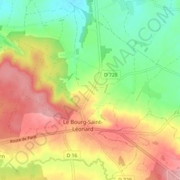
Nombre: Mapa topográfico Le Bourg-Saint-Léonard, altitud, relieve.
Altitud media: 168 m
Altitud mínima: 107 m
Altitud máxima: 234 m
Otros mapas topográficos
Haga clic en un mapa para ver su topografía, su altitud y su relieve.
Exmes
France > Normandie > Orne > Gouffern en Auge
Exmes, Gouffern en Auge, Argentan, Orne, Normandie, France métropolitaine, 61310, France
Altitud media: 196 m
Chambois
France > Normandie > Orne > Gouffern en Auge
Chambois, Gouffern en Auge, Argentan, Orne, Normandie, France métropolitaine, 61160, France
Altitud media: 115 m
Urou-et-Crennes
France > Normandie > Orne > Gouffern en Auge
Urou-et-Crennes, Gouffern en Auge, Argentan, Orne, Normandie, France métropolitaine, 61200, France
Altitud media: 184 m
Aubry-en-Exmes
France > Normandie > Orne > Gouffern en Auge
Aubry-en-Exmes, Gouffern en Auge, Argentan, Orne, Normandie, France métropolitaine, 61160, France
Altitud media: 130 m
Fel
France > Normandie > Orne > Gouffern en Auge
Fel, Gouffern en Auge, Argentan, Orne, Normandie, France métropolitaine, 61160, France
Altitud media: 123 m
Silly-en-Gouffern
France > Normandie > Orne > Gouffern en Auge
Silly-en-Gouffern, Gouffern en Auge, Argentan, Orne, Normandie, France métropolitaine, 61310, France
Altitud media: 176 m