
Haz una donación
Mapa topográfico Austin
Haga clic en el mapa para ver la altitud.
Haz una donación
Austin
Austin is an unincorporated small town in, and former county seat of, Lander County, Nevada, United States. In 2020, the census-designated place of Austin had a population of 167. It is located on the western slopes of the Toiyabe Range at an elevation of 6,575 feet (2,004 m). U.S. Route 50 passes through the town.
Haz una donación
Acerca de este mapa
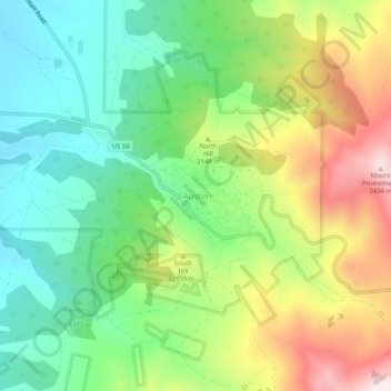
Nombre: Mapa topográfico Austin, altitud, relieve.
Lugar: Austin, Lander County, Nevada, United States (39.47326 -117.08954 39.51326 -117.04954)
Altitud media: 2,076 m
Altitud mínima: 1,841 m
Altitud máxima: 2,464 m
Haz una donación
Otros mapas topográficos
Haga clic en un mapa para ver su topografía, su altitud y su relieve.
Battle Mountain
United States > Nevada > Lander County > Battle Mountain
Battle Mountain's climate is cool semi-arid (Köppen climate classification BSk), receiving just enough precipitation to avoid arid classification. Due to aridity and high elevation, the area commonly experiences large diurnal temperature variation, particularly in summer, when it averages almost 45 °F or 25…
Altitud media: 1,378 m
Battle Mountain
United States > Nevada > Lander County
Battle Mountain's climate is cool semi-arid (Köppen climate classification BSk), receiving just enough precipitation to avoid arid classification. Due to aridity and high elevation, the area commonly experiences large diurnal temperature variation, particularly in summer, when it averages almost 45 °F or 25…
Altitud media: 1,376 m