
Haz una donación
Mapa topográfico Trimley St Martin
Haga clic en el mapa para ver la altitud.
Haz una donación
Trimley St Martin
In 1741 the Suffolk Traveller John Kirby (topographer) surveyed the area around Felixstowe and in his note on Trimley he mentioned 'the lane to the pouch', which led to a small meadow east of the two churches, which contained a spring of clear water, generally regarded the source of Kingsfleet. The stream and can still be seen following out from a concrete opening which was constructed when the Civil Engineers covered the greater part of the meadow with what is now known as the Trimley Roundabout (A14 Junction 59). During dredging of the stream to assist the construction of the by-pass a mill-stone was discovered which was identified as being medieval. The path which runs between a smock mill, which was near Mill Lane, and the top of pouch meadow is called CrowsWell Way
Haz una donación
Acerca de este mapa
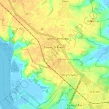
Nombre: Mapa topográfico Trimley St Martin, altitud, relieve.
Altitud media: 15 m
Altitud mínima: -6 m
Altitud máxima: 28 m
Haz una donación
Otros mapas topográficos
Haga clic en un mapa para ver su topografía, su altitud y su relieve.
Gunton Sands
United Kingdom > England > Suffolk > East Suffolk > Lowestoft > Corton
Altitud media: 10 m
Haz una donación
Sutton Hoo Archeological Site
United Kingdom > England > Suffolk > East Suffolk > Sutton
Altitud media: 19 m
Lowestoft Inner Harbour
United Kingdom > England > Suffolk > East Suffolk > Lowestoft > Oulton Broad
Altitud media: 8 m
Haz una donación
Site of old Orfordness Lighthouse
United Kingdom > England > Suffolk > East Suffolk > Orford
Altitud media: 0 m
Rendlesham UFO Landing Site #2
United Kingdom > England > Suffolk > East Suffolk > Butley Abbey
Altitud media: 14 m
Haz una donación
Haz una donación
Haz una donación
Haz una donación