
Mapa topográfico Idar-Oberstein
Mapa interactivo
Haga clic en el mapa para ver la altitud.
Acerca de este mapa
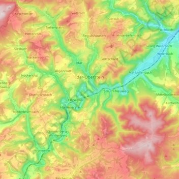
Nombre: Mapa topográfico Idar-Oberstein, altitud, relieve.
Altitud media: 406 m
Altitud mínima: 210 m
Altitud máxima: 617 m
Idar-Oberstein/Göttschied Airfield lies north of the town between the constituent community of Göttschied and the municipalities of Gerach and Hintertiefenbach at an elevation of 480 m above sea level (1,575 feet). Its ICAO location indicator is EDRG. The grass landing strip's orientation is 06/24, and it is 650 m long and 50 m wide. The allowable landing weight is 2 000 kg; however, with PPR (“prior permission required”), aircraft of up to 3 700 kg may land. The airport is designed for helicopters, motor gliders, gliders, ultralights and, also with PPR, skydivers.
Otros mapas topográficos
Haga clic en un mapa para ver su topografía, su altitud y su relieve.
Mittelreidenbach
Germany > Rhineland-Palatinate > Landkreis Birkenfeld
Mittelreidenbach, Herrstein-Rhaunen, Landkreis Birkenfeld, Rhineland-Palatinate, Germany
Altitud media: 340 m
Hallenbad Idar-Oberstein
Germany > Rhineland-Palatinate > Landkreis Birkenfeld > Idar-Oberstein
Hallenbad Idar-Oberstein, 213, Hauptstraße, Idar, Idar-Oberstein, Landkreis Birkenfeld, Rhineland-Palatinate, 55743, Germany
Altitud media: 343 m
Baumholder
Germany > Rhineland-Palatinate > Landkreis Birkenfeld
Baumholder, Landkreis Birkenfeld, Rhineland-Palatinate, 55774, Germany
Altitud media: 451 m
Heimbach
Germany > Rhineland-Palatinate > Landkreis Birkenfeld
Heimbach, Baumholder, Landkreis Birkenfeld, Rhineland-Palatinate, Germany
Altitud media: 412 m
Gollenberg
Germany > Rhineland-Palatinate > Landkreis Birkenfeld
Gollenberg, Birkenfeld, Landkreis Birkenfeld, Rhineland-Palatinate, Germany
Altitud media: 466 m