
Gracias por apoyar a este sitio ❤️
Haz una donación
Haz una donación
Mapa topográfico Heber
Haga clic en el mapa para ver la altitud.
Gracias por apoyar a este sitio ❤️
Haz una donación
Haz una donación
Heber
Heber City is located at 40°30′24″N 111°24′44″W / 40.506793°N 111.412292°W / 40.506793; -111.412292 (40.506793, -111.412292), at an elevation of 5595 feet. The region in which Heber City is located is known as the Wasatch Back.
Gracias por apoyar a este sitio ❤️
Haz una donación
Haz una donación
Acerca de este mapa
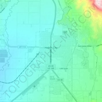
Nombre: Mapa topográfico Heber, altitud, relieve.
Lugar: Heber, Wasatch County, Utah, 84032, United States (40.47148 -111.44473 40.53675 -111.35712)
Altitud media: 1,737 m
Altitud mínima: 1,662 m
Altitud máxima: 2,170 m
Gracias por apoyar a este sitio ❤️
Haz una donación
Haz una donación
Otros mapas topográficos
Haga clic en un mapa para ver su topografía, su altitud y su relieve.