
Mapa topográfico Brookhaven
Mapa interactivo
Haga clic en el mapa para ver la altitud.
Acerca de este mapa
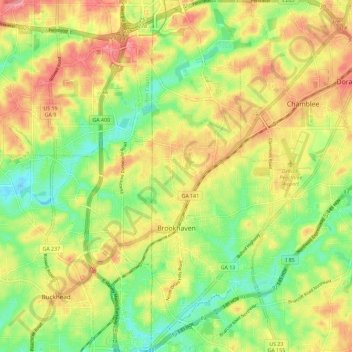
Nombre: Mapa topográfico Brookhaven, altitud, relieve.
Lugar: Brookhaven, DeKalb County, Georgia, United States (33.82478 -84.34852 33.92020 -84.30816)
Altitud media: 293 m
Altitud mínima: 248 m
Altitud máxima: 339 m
Otros mapas topográficos
Haga clic en un mapa para ver su topografía, su altitud y su relieve.
Candler-McAfee
United States > Georgia > DeKalb County
Candler-McAfee, DeKalb County, Georgia, 30032, United States
Altitud media: 288 m
Avondale Estates
United States > Georgia > DeKalb County
Avondale Estates, DeKalb County, Georgia, United States
Altitud media: 313 m
Tucker
United States > Georgia > DeKalb County > Tucker
Tucker, DeKalb County, Georgia, 30084, United States
Altitud media: 317 m
Dunwoody
United States > Georgia > DeKalb County
Dunwoody, DeKalb County, Georgia, United States
Altitud media: 313 m
Chamblee
United States > Georgia > DeKalb County
Chamblee, DeKalb County, Georgia, 30341, United States
Altitud media: 297 m
Redan
United States > Georgia > DeKalb County > Redan
Redan, DeKalb County, Georgia, 30088-3433, United States
Altitud media: 283 m
Pinehurst
United States > Georgia > DeKalb County > Pinehurst
Pinehurst, DeKalb County, Georgia, 30034-5209, United States
Altitud media: 257 m
Clarkston
United States > Georgia > DeKalb County > Clarkston
Clarkston, DeKalb County, Georgia, 30021, United States
Altitud media: 307 m