
Haz una donación
Mapa topográfico Rexville
Haga clic en el mapa para ver la altitud.
Haz una donación
Acerca de este mapa
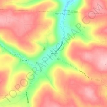
Nombre: Mapa topográfico Rexville, altitud, relieve.
Altitud media: 649 m
Altitud mínima: 527 m
Altitud máxima: 725 m
Haz una donación
Otros mapas topográficos
Haga clic en un mapa para ver su topografía, su altitud y su relieve.
Haz una donación
City of Hornell
United States > New York > Steuben County
Hornell is located at 42°19′N 77°40′W / 42.317°N 77.667°W / 42.317; -77.667 (42.3244, -77.6603). Hornell is at an altitude of 1,160 feet (350 meters) above sea level.
Altitud media: 461 m
Haz una donación
Town of Prattsburgh
United States > New York > Steuben County
The town is at a higher altitude than most other parts of the county.
Altitud media: 517 m
Haz una donación
Village of Hammondsport
United States > New York > Steuben County
Beginning in 1894 Hammondsport received its first water system from springs that were contained in the Rufus Scofield farm, on Mt. Washington, not far from the village. Aside from supplying the village with pure spring water, one of the first objectives was to install five fire hydrants at convenient locations…
Altitud media: 288 m
Haz una donación
Haz una donación
Coopers Plains
United States > New York > Steuben County > Town of Campbell > Coopers Plains
Altitud media: 348 m
Haz una donación