
Mapa topográfico Biltmore
Mapa interactivo
Haga clic en el mapa para ver la altitud.
Acerca de este mapa
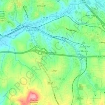
Nombre: Mapa topográfico Biltmore, altitud, relieve.
Altitud media: 650 m
Altitud mínima: 602 m
Altitud máxima: 742 m
Otros mapas topográficos
Haga clic en un mapa para ver su topografía, su altitud y su relieve.
Biltmore Village
United States > North Carolina > Buncombe County > Asheville
Biltmore Village, Asheville, Buncombe County, North Carolina, 28802, United States
Altitud media: 642 m
Albemarle
United States > North Carolina > Buncombe County > Asheville
Albemarle, Asheville, Buncombe County, North Carolina, 28802, United States
Altitud media: 718 m
Royal Pines
United States > North Carolina > Buncombe County > Asheville
Royal Pines, Asheville, Buncombe County, North Carolina, 28776, United States
Altitud media: 700 m
Redwood Village
United States > North Carolina > Buncombe County > Asheville
Redwood Village, Asheville, Buncombe County, North Carolina, 28805, United States
Altitud media: 657 m
Aston Park
United States > North Carolina > Buncombe County > Asheville > River Arts District
Aston Park, River Arts District, Asheville, Buncombe County, North Carolina, 28801, United States
Altitud media: 641 m
Kenilworth
United States > North Carolina > Buncombe County > Asheville
Kenilworth, Asheville, Buncombe County, North Carolina, 28802, United States
Altitud media: 648 m
Deaver View
United States > North Carolina > Buncombe County > Asheville
Deaver View, Asheville, Buncombe County, North Carolina, 28806, United States
Altitud media: 678 m