
Mapa topográfico La Salcette
Mapa interactivo
Haga clic en el mapa para ver la altitud.
Acerca de este mapa
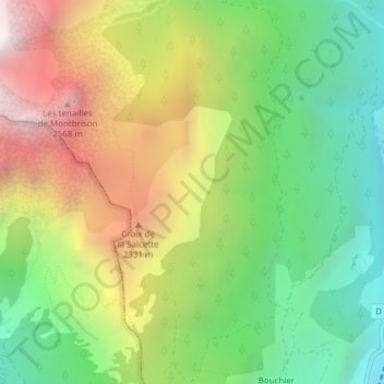
Nombre: Mapa topográfico La Salcette, altitud, relieve.
Altitud media: 1,834 m
Altitud mínima: 1,163 m
Altitud máxima: 2,754 m
Otros mapas topográficos
Haga clic en un mapa para ver su topografía, su altitud y su relieve.
Ratière
France > Provence-Alpes-Côte d'Azur > Hautes-Alpes > Saint-Martin-de-Queyrières
Ratière, Saint-Martin-de-Queyrières, Briançon, Hautes-Alpes, Provence-Alpes-Côte d'Azur, France métropolitaine, 05120, France
Altitud media: 1,723 m
Sainte-Marguerite
France > Provence-Alpes-Côte d'Azur > Hautes-Alpes > Saint-Martin-de-Queyrières
Sainte-Marguerite, Saint-Martin-de-Queyrières, Briançon, Hautes-Alpes, Provence-Alpes-Côte d'Azur, France métropolitaine, 05120, France
Altitud media: 1,453 m
Roche Baron
France > Provence-Alpes-Côte d'Azur > Hautes-Alpes > Saint-Martin-de-Queyrières
Roche Baron, Saint-Martin-de-Queyrières, Briançon, Hautes-Alpes, Provence-Alpes-Côte d'Azur, France métropolitaine, 05120, France
Altitud media: 1,512 m