
Gracias por apoyar a este sitio ❤️
Haz una donación
Haz una donación
Mapa topográfico Grays Peak
Haga clic en el mapa para ver la altitud.
Gracias por apoyar a este sitio ❤️
Haz una donación
Haz una donación
Grays Peak
Grays Peak is one of 53 fourteeners (mountains of over 14,000 feet (4,300 m) in elevation) in Colorado. Botanist Charles C. Parry made the first recorded ascent of the summit in 1861 and named the peak in honor of his botanist colleague Asa Gray. Gray did not see (and climb) the peak until 1872, eleven years later. Grays Peak is commonly mentioned in conjunction with adjacent Torreys Peak.
Gracias por apoyar a este sitio ❤️
Haz una donación
Haz una donación
Acerca de este mapa
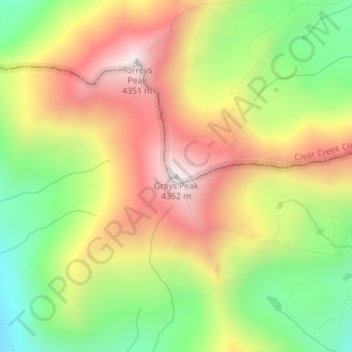
Nombre: Mapa topográfico Grays Peak, altitud, relieve.
Lugar: Grays Peak, Clear Creek County, Colorado, United States (39.63383 -105.81756 39.63393 -105.81746)
Altitud media: 3,914 m
Altitud mínima: 3,497 m
Altitud máxima: 4,341 m
Gracias por apoyar a este sitio ❤️
Haz una donación
Haz una donación
Otros mapas topográficos
Haga clic en un mapa para ver su topografía, su altitud y su relieve.