
Mapa topográfico Valencia
Mapa interactivo
Haga clic en el mapa para ver la altitud.
Valencia
The city's topography is characterized as flat to undulating hills with extensive plateaus and mountainous areas and cliffs on both eastern and western portions bounding the municipality of San Fernando on the east and the municipality of Talakag on the west. Its highest point is Mount Kalatungan in the Kalatungan Mountain Range rising above 1,000 meters and above 50 percent slopes. These cover 25.72 percent of the total city area and major portions of Barangay of Lourdes, Guinoyuran and Lilingayon.
Acerca de este mapa
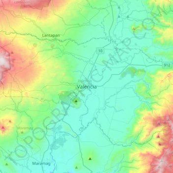
Nombre: Mapa topográfico Valencia, altitud, relieve.
Lugar: Valencia, Bukidnon, Northern Mindanao, 8709, Philippines (7.74288 124.92980 8.06288 125.24980)
Altitud media: 566 m
Altitud mínima: 222 m
Altitud máxima: 1,690 m
Otros mapas topográficos
Haga clic en un mapa para ver su topografía, su altitud y su relieve.
Lake Apo
Philippines > Bukidnon > Valencia
Lake Apo is a crater lake in Barangay Guinoyoran in the city of Valencia in Bukidnon province in the Philippines. It is located in a hilly area about 640 metres (2,100 ft) in elevation, about 11 kilometres (6.8 mi) WSW of the city poblacion (town center). Lake Apo was awarded the cleanest inland body of water…
Altitud media: 643 m