
Mapa topográfico Bayog
Mapa interactivo
Haga clic en el mapa para ver la altitud.
Bayog
The town is partly situated in the Sibougey Valley watered by the Sibuguey River, Dipili River, and Depore River. 75% of the land lies on rugged terrain with elevation up to 300 metres (980 ft).
Acerca de este mapa
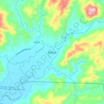
Nombre: Mapa topográfico Bayog, altitud, relieve.
Altitud media: 137 m
Altitud mínima: 26 m
Altitud máxima: 485 m
Otros mapas topográficos
Haga clic en un mapa para ver su topografía, su altitud y su relieve.