
Mapa topográfico Charles River
Mapa interactivo
Haga clic en el mapa para ver la altitud.
Acerca de este mapa
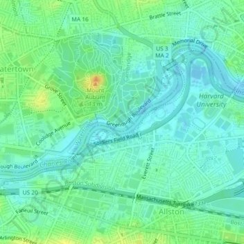
Nombre: Mapa topográfico Charles River, altitud, relieve.
Altitud media: 10 m
Altitud mínima: -2 m
Altitud máxima: 31 m
As native populations were driven out by European settlers, the Charles River became an early center for hydropower and manufacturing in North America. Although in portions of its length, the Charles drops slowly in elevation and has relatively little current, early settlers in Dedham, Massachusetts, found a way to use the Charles to power mills. In 1639, the town dug a canal from the Charles to a nearby brook that drained to the Neponset River. By this action, a portion of the Charles's flow was diverted, providing enough current for several mills. The new canal and the brook together are now called Mother Brook. The canal is regarded as the first industrial canal in North America. It remains in use for flood control.
Otros mapas topográficos
Haga clic en un mapa para ver su topografía, su altitud y su relieve.
Brighton
United States > Massachusetts > Suffolk County > Boston
Brighton, Boston, Suffolk County, Massachusetts, 02135, United States
Altitud media: 31 m
Bunker Hill Monument
United States > Massachusetts > Suffolk County > Boston
Bunker Hill Monument, Monument Square, Charlestown, Boston, Suffolk County, Massachusetts, 02129, United States
Altitud media: 6 m
Boston Harbor
United States > Massachusetts > Suffolk County > Boston
Boston Harbor, Boston, Suffolk County, Massachusetts, 02152, United States
Altitud media: 1 m
Prescott Square
United States > Massachusetts > Suffolk County > Boston
Prescott Square, Eagle Hill, East Boston, Boston, Suffolk County, Massachusetts, United States
Altitud media: 7 m
Savin Hill Park
United States > Massachusetts > Suffolk County > Boston
Savin Hill Park, Savin Hill, Dorchester, Boston, Suffolk County, Massachusetts, United States
Altitud media: 7 m
Jamaica Pond
United States > Massachusetts > Suffolk County > Boston
Jamaica Pond, Jamaica Plain, Boston, Suffolk County, Massachusetts, United States
Altitud media: 34 m
Bellevue Hill
United States > Massachusetts > Suffolk County > Boston
Bellevue Hill, Boston, Suffolk County, Massachusetts, 02132, United States
Altitud media: 51 m
Bunker Hill
United States > Massachusetts > Suffolk County > Boston
Bunker Hill, Boston, Suffolk County, Massachusetts, 02129, United States
Altitud media: 6 m
Franklin Park
United States > Massachusetts > Suffolk County > Boston
Franklin Park, Roxbury, Boston, Suffolk County, Massachusetts, United States
Altitud media: 30 m
Breeds Hill
United States > Massachusetts > Suffolk County > Boston
Breeds Hill, Boston, Suffolk County, Massachusetts, 02129, United States
Altitud media: 6 m
Little Brewster Island
United States > Massachusetts > Suffolk County > Boston
Little Brewster Island, Boston, Suffolk County, Massachusetts, United States
Altitud media: 0 m
Spectacle Island
United States > Massachusetts > Suffolk County > Boston
Spectacle Island, Boston, Suffolk County, Massachusetts, United States
Altitud media: 1 m
Georges Island
United States > Massachusetts > Suffolk County > Boston
Georges Island, Boston, Suffolk County, Massachusetts, 02045, United States
Altitud media: 25 m
Pleasure Bay
United States > Massachusetts > Suffolk County > Boston
Pleasure Bay, Boston, Suffolk County, Massachusetts, 02127, United States
Altitud media: 2 m