
Haz una donación
Mapa topográfico Leutzdorf
Haga clic en el mapa para ver la altitud.
Haz una donación
Leutzdorf
Allersdorf | Altenthal | Behringersmühle | Bösenbirkig | Etzdorf | Geiselhöhe | Gößweinstein | Hardt | Hartenreuth | Hühnerloh | Hungenberg | Kleingesee | Kohlstein | Leimersberg | Leutzdorf | Liebenau | Moritz | Morschreuth | Moschendorf | Prügeldorf | Sachsendorf | Sachsendorf-Straßhüll | Sachsenmühle | Sattelmannsburg | Schweigelberg | Stadelhofen | Stempfermühle | Türkelstein | Ühleinshof | Unterailsfeld | Wichsenstein | Wölm
Haz una donación
Acerca de este mapa
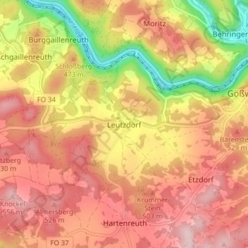
Nombre: Mapa topográfico Leutzdorf, altitud, relieve.
Altitud media: 458 m
Altitud mínima: 310 m
Altitud máxima: 551 m
Haz una donación
Otros mapas topográficos
Haga clic en un mapa para ver su topografía, su altitud y su relieve.
91327
Deutschland > Bayern > Landkreis Forchheim > Gößweinstein > Behringersmühle > Stempfermühle
Altitud media: 461 m