
Mapa topográfico Covelo
Mapa interactivo
Haga clic en el mapa para ver la altitud.
Acerca de este mapa
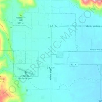
Nombre: Mapa topográfico Covelo, altitud, relieve.
Lugar: Covelo, Mendocino County, California, 95428, United States (39.78042 -123.28683 39.82439 -123.21033)
Altitud media: 440 m
Altitud mínima: 407 m
Altitud máxima: 673 m
Covelo (/ˈkoʊvəloʊ/ KOH-və-loh) is a census-designated place (CDP) in Mendocino County, California, United States. Covelo is located 14 miles (23 km) east-northeast of Laytonville, at an elevation of 1,398 feet (426 m). The population was 1,394 at the 2020 census, up from 1,255 at the 2010 census. 405 acres (1.64 km2) of Covelo is part of the Round Valley Indian Reservation.