
Gracias por apoyar a este sitio ❤️
Haz una donación
Haz una donación
Mapa topográfico Command Ridge
Haga clic en el mapa para ver la altitud.
Gracias por apoyar a este sitio ❤️
Haz una donación
Haz una donación
Command Ridge
Command Ridge is the highest point of Nauru, with an elevation of 65 metres (213 ft).
Gracias por apoyar a este sitio ❤️
Haz una donación
Haz una donación
Acerca de este mapa
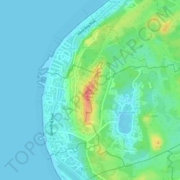
Nombre: Mapa topográfico Command Ridge, altitud, relieve.
Lugar: Command Ridge, Orro, Aiwo District, Aiwo, Nauru (-0.53052 166.91687 -0.53042 166.91697)
Altitud media: 17 m
Altitud mínima: -1 m
Altitud máxima: 68 m
Gracias por apoyar a este sitio ❤️
Haz una donación
Haz una donación