
Mapa topográfico Kerjean
Mapa interactivo
Haga clic en el mapa para ver la altitud.
Acerca de este mapa
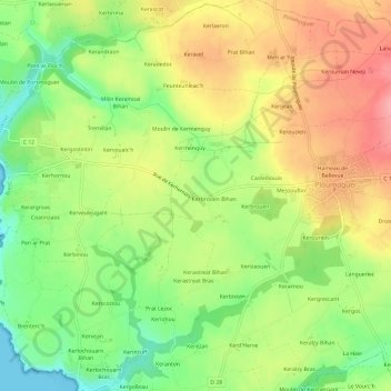
Nombre: Mapa topográfico Kerjean, altitud, relieve.
Altitud media: 54 m
Altitud mínima: 0 m
Altitud máxima: 110 m
Otros mapas topográficos
Haga clic en un mapa para ver su topografía, su altitud y su relieve.
Brenterc'h
France > Bretagne > Finistère > Ploumoguer
Brenterc'h, Ploumoguer, Brest, Finistère, Bretagne, France métropolitaine, 29810, France
Altitud media: 21 m
Le Bourg
France > Bretagne > Finistère > Ploumoguer
Le Bourg, Ploumoguer, Brest, Finistère, Bretagne, France métropolitaine, 29810, France
Altitud media: 71 m
Kerichen
France > Bretagne > Finistère > Ploumoguer
Kerichen, Ploumoguer, Brest, Finistère, Bretagne, France métropolitaine, 29810, France
Altitud media: 28 m
Hameau de Bel Air
France > Bretagne > Finistère > Ploumoguer
Hameau de Bel Air, Ploumoguer, Brest, Finistère, Bretagne, France métropolitaine, 29810, France
Altitud media: 73 m
Kerouman
France > Bretagne > Finistère > Ploumoguer
Kerouman, Ploumoguer, Brest, Finistère, Bretagne, France métropolitaine, 29810, France
Altitud media: 74 m
Kerhornou
France > Bretagne > Finistère > Ploumoguer
Kerhornou, Ploumoguer, Brest, Finistère, Bretagne, France métropolitaine, 29810, France
Altitud media: 35 m