
Mapa topográfico Calbayog
Haga clic en el mapa para ver la altitud.
Calbayog
Forty percent of the city's land area are plain and hilly terrains with elevation ranging from 5 to 20 metres (16 to 66 ft) above sea level. The rest are rugged mountain ranges with elevations from 300 to 700 metres (980 to 2,300 ft) above sea level. Flooding is minimized because of many rivers, brooks, streams and natural water conveyors that flow towards the sea.
Acerca de este mapa
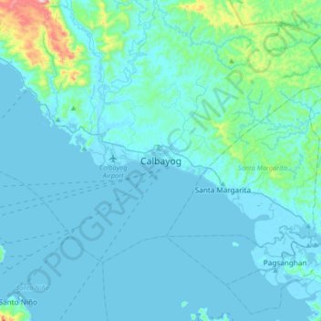
Nombre: Mapa topográfico Calbayog, altitud, relieve.
Lugar: Calbayog, Samar, Eastern Visayas, 6710, Philippines (11.90696 124.43467 12.22696 124.75467)
Altitud media: 55 m
Altitud mínima: -2 m
Altitud máxima: 662 m
Otros mapas topográficos
Haga clic en un mapa para ver su topografía, su altitud y su relieve.