
Gracias por apoyar a este sitio ❤️
Haz una donación
Haz una donación
Mapa topográfico Kavaratti Island
Haga clic en el mapa para ver la altitud.
Gracias por apoyar a este sitio ❤️
Haz una donación
Haz una donación
Kavaratti Island
The island of Kavaratti lies 360 km (190 nmi) off the coast of the state of Kerala at 10°34′N 72°38′E / 10.57°N 72.64°E / 10.57; 72.64. It has an average elevation of 0 metres (0 feet).
Gracias por apoyar a este sitio ❤️
Haz una donación
Haz una donación
Acerca de este mapa
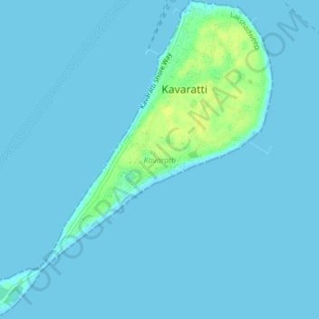
Nombre: Mapa topográfico Kavaratti Island, altitud, relieve.
Lugar: Kavaratti Island, Kavaratti, Lakshadweep, 262240, India (10.54073 72.61545 10.57747 72.64979)
Altitud media: 2 m
Altitud mínima: 0 m
Altitud máxima: 17 m
Gracias por apoyar a este sitio ❤️
Haz una donación
Haz una donación