
Haz una donación
Mapa topográfico Douglas
Haga clic en el mapa para ver la altitud.
Haz una donación
Douglas
Douglas has a record of its elevation above sea level of 1030.22 meters (3379.99 feet). Comparing Douglas district's yearly temperature to South Africa's averages, the records show that it is 4.01% higher with a temperature 25.23 °C (77.41 °F). Douglas is known for its Subtropical desert climate with 38.78 rainy days (10.62% of the time) and precipitation of about 19.31 millimeters (0.76 inches) annually.
Haz una donación
Acerca de este mapa
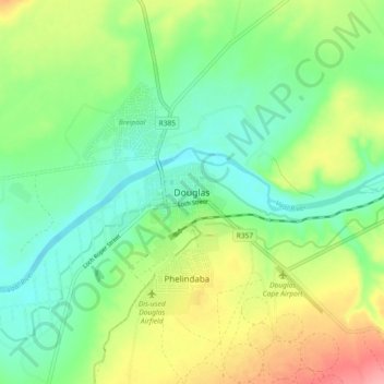
Nombre: Mapa topográfico Douglas, altitud, relieve.
Altitud media: 1,010 m
Altitud mínima: 975 m
Altitud máxima: 1,072 m
Haz una donación
Otros mapas topográficos
Haga clic en un mapa para ver su topografía, su altitud y su relieve.
Mokala National Park
South Africa > Northern Cape > Pixley ka Seme District Municipality > Siyancuma Local Municipality
The Northern Cape is a dry region with fluctuating temperatures and differing topographies. The weather is typically that of desert and semi-desert areas. The annual rainfall is never high (between 300–500 mm, average 400 mm) and is always lower than the rate of evaporation. Summers (from December to…
Altitud media: 1,169 m
Boegoeberg Dam
South Africa > Northern Cape > Pixley ka Seme District Municipality > Siyancuma Local Municipality
Altitud media: 935 m