
Mapa topográfico Weston
Mapa interactivo
Haga clic en el mapa para ver la altitud.
Acerca de este mapa
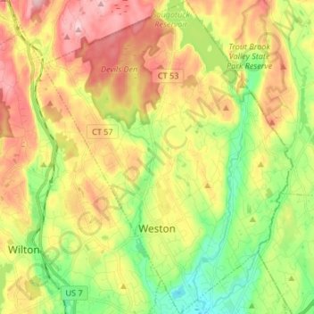
Nombre: Mapa topográfico Weston, altitud, relieve.
Altitud media: 98 m
Altitud mínima: 4 m
Altitud máxima: 206 m
Otros mapas topográficos
Haga clic en un mapa para ver su topografía, su altitud y su relieve.
Harborview
United States > Connecticut > Western Connecticut COG > Norwalk
Harborview, Norwalk, Western Connecticut COG, Connecticut, 06855, United States
Altitud media: 6 m
Brookfield
United States > Connecticut > Western Connecticut COG
Brookfield, Western Connecticut COG, Connecticut, 06804, United States
Altitud media: 139 m
Cedar Heights
United States > Connecticut > Western Connecticut COG > Danbury
Cedar Heights, Danbury, Western Connecticut COG, Connecticut, 06804, United States
Altitud media: 145 m
Bethel
United States > Connecticut > Western Connecticut COG > Bethel
Bethel, Western Connecticut COG, Connecticut, 06801, United States
Altitud media: 144 m
High Ridge
United States > Connecticut > Western Connecticut COG > Stamford
High Ridge, Stamford, Western Connecticut COG, Connecticut, 06903, United States
Altitud media: 119 m