
Mapa topográfico Ranebennur
Haga clic en el mapa para ver la altitud.
Ranebennur
Ranebennuru is at the geographical center of Karnataka. 14°37′N 75°37′E / 14.62°N 75.62°E / 14.62; 75.62. It has an average elevation of 605 metres (1,985 ft). One of Karnataka's most important rivers – the Tungabhadra – flows along the southern border of Ranebennur taluk. Another river, the Kumadvathi, which originates from Madagh Masur Lake flows from Hirekerur taluk, enters Ranebennur taluk, and joins the Tungabhadra river.
Acerca de este mapa
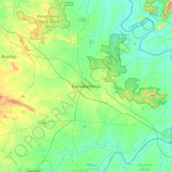
Nombre: Mapa topográfico Ranebennur, altitud, relieve.
Altitud media: 574 m
Altitud mínima: 509 m
Altitud máxima: 785 m