
Haz una donación
Mapa topográfico Dane County
Haga clic en el mapa para ver la altitud.
Haz una donación
Dane County
Dane County showcases a diverse topography characterized by its rolling hills and numerous lakes, primarily shaped by glacial activity during the last Ice Age. The terrain varies significantly, with elevations ranging from approximately 860 feet to 1,200 feet above sea level. The county is famously known for the Yahara River chain of lakes, which includes Lakes Mendota, Monona, Waubesa, and Kegonsa, forming an "isthmus" in Madison. This river system, combined with the surrounding hills, creates a picturesque landscape that is both scenic and ecologically rich. In addition to the lakes, the county features numerous parks and natural areas that highlight its topographical variety, including woodlands and prairies, contributing to the region's biodiversity and recreational opportunities.
Haz una donación
Acerca de este mapa
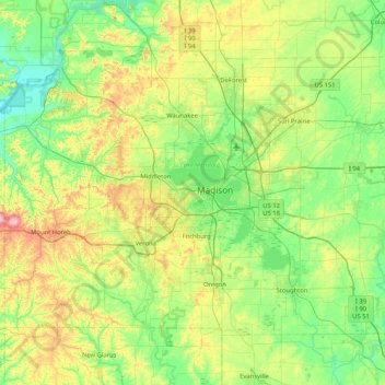
Nombre: Mapa topográfico Dane County, altitud, relieve.
Lugar: Dane County, Wisconsin, United States (42.84515 -89.83857 43.29416 -89.00883)
Altitud media: 289 m
Altitud mínima: 218 m
Altitud máxima: 477 m
Haz una donación
Otros mapas topográficos
Haga clic en un mapa para ver su topografía, su altitud y su relieve.
Wildcat Mountain State Park
United States > Wisconsin > Vernon County > Town of Whitestown
Altitud media: 310 m
Haz una donación
Haz una donación
Milwaukee River Floodplain Forest State Natural Area
United States > Wisconsin > Washington County
Altitud media: 291 m
Haz una donación
Haz una donación
Haz una donación
Haz una donación
Parfrey's Glen State Natural Area
United States > Wisconsin > Sauk County > Town of Merrimac
Altitud media: 360 m
Haz una donación
Haz una donación
Northern Wisconsin State Fairgrounds
United States > Wisconsin > Chippewa County > Chippewa Falls
Altitud media: 279 m
Haz una donación
Haz una donación
Haz una donación
Haz una donación
Haz una donación
Haz una donación
Haz una donación
George W Mead State Wildlife Management Area
United States > Wisconsin > Marathon County > Town of Bergen
Altitud media: 343 m
Haz una donación
Haz una donación
Yellowstone Lake State Park
United States > Wisconsin > Lafayette County > Blanchardville > Town of Fayette
Altitud media: 288 m
Haz una donación
Haz una donación
Wildcat Mountain State Park
United States > Wisconsin > Vernon County > Town of Whitestown
Altitud media: 310 m
Haz una donación
Haz una donación
Marinette County Beech Forest State Natural Area
United States > Wisconsin > Marinette County
Altitud media: 371 m
Haz una donación
Haz una donación
Perrot State Park
United States > Wisconsin > Trempealeau County > Town of Trempealeau
Altitud media: 223 m
Haz una donación
Haz una donación