
Mapa topográfico College Park
Mapa interactivo
Haga clic en el mapa para ver la altitud.
Acerca de este mapa
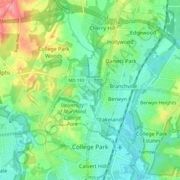
Nombre: Mapa topográfico College Park, altitud, relieve.
Altitud media: 38 m
Altitud mínima: 10 m
Altitud máxima: 100 m
The Lakeland neighborhood was developed beginning in 1892 around the Baltimore and Ohio Railroad, whose Branchville and Calvert Road depots were located approximately one mile to the north and south, respectively. Lakeland was created by Edwin Newman, who improved the original 238 acres (0.96 km2) located to the west of the railroad. He also built a number of the original homes, a small town hall, and a general store. The area was originally envisioned as a resort-type community. However, due to the flood-prone, low-lying topography, the neighborhood attracted a lower-income population and became an area for African-American settlement. Around 1900, the Baltimore Gold Fish Company built five artificial lakes in the area to spawn goldfish and rarer species of fish. A one-room school was built in 1903 for the African-American population; a new school was built in 1925.