
Mapa topográfico Greenhills
Mapa interactivo
Haga clic en el mapa para ver la altitud.
Greenhills
Greenhills and the adjacent West Crame are the only barangays in San Juan that are not entirely situated on tuff and tuffaceous sedimentary rock, with parts of the barangay being situated on top of pyroclastic flow adobe deposits. The highest elevation of San Juan can be found in Greenhills at its border with Quezon City's Barangay Camp Aguinaldo along EDSA, peaking at 34 meters (112 ft) above sea level.
Acerca de este mapa
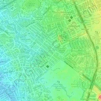
Nombre: Mapa topográfico Greenhills, altitud, relieve.
Altitud media: 32 m
Altitud mínima: 8 m
Altitud máxima: 61 m
Otros mapas topográficos
Haga clic en un mapa para ver su topografía, su altitud y su relieve.
San Juan
"San Juan City" is a contraction of the city's traditional name of "San Juan del Monte" (lit. Saint John of the Mountain). As with numerous other places in the Philippines, the name combines a patron saint and a toponym; in this case Saint John the Baptist with the locale's hilly terrain and relatively…
Altitud media: 35 m