
Mapa topográfico Spinney Hill Park
Mapa interactivo
Haga clic en el mapa para ver la altitud.
Acerca de este mapa
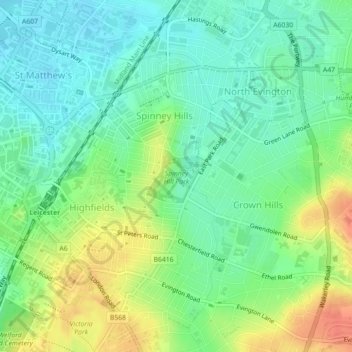
Nombre: Mapa topográfico Spinney Hill Park, altitud, relieve.
Altitud media: 73 m
Altitud mínima: 55 m
Altitud máxima: 101 m
Otros mapas topográficos
Haga clic en un mapa para ver su topografía, su altitud y su relieve.
Grand Union Canal
United Kingdom > England > Leicester
Grand Union Canal, Leicester, City of Leicester, East Midlands, England, LE3 5EP, United Kingdom
Altitud media: 65 m
Western Park
United Kingdom > England > Leicester
Western Park, New Parks, Leicester, City of Leicester, East Midlands, England, LE3 6HX, United Kingdom
Altitud media: 88 m
Castle Hill Country Park
United Kingdom > England > Leicester
Castle Hill Country Park, Bradgate Heights, Leicester, City of Leicester, East Midlands, England, United Kingdom
Altitud media: 81 m