
Mapa topográfico Lakhimpur
Haga clic en el mapa para ver la altitud.
Lakhimpur
Lakhimpur is located at 27°57′N 80°46′E / 27.95°N 80.77°E / 27.95; 80.77. It has an average elevation of 147 metres (482 ft).
Acerca de este mapa
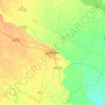
Nombre: Mapa topográfico Lakhimpur, altitud, relieve.
Altitud media: 141 m
Altitud mínima: 126 m
Altitud máxima: 155 m
Otros mapas topográficos
Haga clic en un mapa para ver su topografía, su altitud y su relieve.
Mahakali River
India > Uttar Pradesh > Lakhimpur
The Sharda River is the downstream of Kāli River (or Mahakali River) that originates in the northern Uttarakhand state of India in the Great Himalayas on the eastern slopes of Nanda Devi massif, at an elevation of 3,600 m (11,800 ft) in the Pithoragarh district. It then flows on the Nepal and India border.…
Altitud media: 135 m