
Gracias por apoyar a este sitio ❤️
Haz una donación
Haz una donación
Mapa topográfico Island East River
Haga clic en el mapa para ver la altitud.
Gracias por apoyar a este sitio ❤️
Haz una donación
Haz una donación
Acerca de este mapa
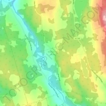
Nombre: Mapa topográfico Island East River, altitud, relieve.
Altitud media: 104 m
Altitud mínima: 27 m
Altitud máxima: 204 m
Gracias por apoyar a este sitio ❤️
Haz una donación
Haz una donación
Otros mapas topográficos
Haga clic en un mapa para ver su topografía, su altitud y su relieve.
Gracias por apoyar a este sitio ❤️
Haz una donación
Haz una donación
Gracias por apoyar a este sitio ❤️
Haz una donación
Haz una donación
Gracias por apoyar a este sitio ❤️
Haz una donación
Haz una donación
Gracias por apoyar a este sitio ❤️
Haz una donación
Haz una donación
Gracias por apoyar a este sitio ❤️
Haz una donación
Haz una donación
Gracias por apoyar a este sitio ❤️
Haz una donación
Haz una donación
Gracias por apoyar a este sitio ❤️
Haz una donación
Haz una donación
Pictou Island
Canada > Nova Scotia > Municipality of Pictou County
Pictou Island is a Canadian island located in the Northumberland Strait approximately seven kilometres (four nautical miles) north of Nova Scotia and nineteen kilometres (ten nautical miles) south of Prince Edward Island. The island has a length of 9.5 km (5.9 mi), a width of 2.5 km (1.6 mi) and a total area…
Altitud media: 2 m
Gracias por apoyar a este sitio ❤️
Haz una donación
Haz una donación
Gracias por apoyar a este sitio ❤️
Haz una donación
Haz una donación
Gracias por apoyar a este sitio ❤️
Haz una donación
Haz una donación
Gracias por apoyar a este sitio ❤️
Haz una donación
Haz una donación