
Haz una donación
Mapa topográfico Egham Hythe
Haga clic en el mapa para ver la altitud.
Haz una donación
Acerca de este mapa
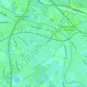
Nombre: Mapa topográfico Egham Hythe, altitud, relieve.
Altitud media: 16 m
Altitud mínima: 10 m
Altitud máxima: 26 m
Haz una donación
Otros mapas topográficos
Haga clic en un mapa para ver su topografía, su altitud y su relieve.
Cooper's Hill Slopes
United Kingdom > England > Surrey > Borough of Runnymede > Englefield Green
Altitud media: 38 m
Haz una donación
Addlestone
United Kingdom > England > Surrey > Borough of Runnymede
Elevations range between 11 metres (36 ft) and 40 metres (130 ft). The maximum is on Row Hill recreation ground, Row Town, Addlestone; a ridge that continues to the northwest of Row Town where it is known as Ongar/Spinney Hill, where Great Grove Farm in its centre also reaches this height; the minimum is by…
Altitud media: 18 m
Chertsey
United Kingdom > England > Surrey > Borough of Runnymede
Samuel Lewis devotes one of his longest entries to the small town in his 1848 topographical guide to England.
Altitud media: 17 m
Haz una donación
Chertsey
United Kingdom > England > Surrey > Borough of Runnymede
Samuel Lewis devotes one of his longest entries to the small town in his 1848 topographical guide to England.
Altitud media: 22 m
Egham Wick
United Kingdom > England > Surrey > Borough of Runnymede > Englefield Green
Altitud media: 55 m
Haz una donación
Haz una donación
Haz una donación
Addlestone
United Kingdom > England > Surrey > Borough of Runnymede
Elevations range between 11 and 40 metres (36 and 131 ft). The maximum is on Row Hill recreation ground, Row Town, Addlestone; a ridge that continues to the northwest of Row Town where it is known as Ongar/Spinney Hill, where Great Grove Farm in its centre also reaches this height; the minimum is by the Thames…
Altitud media: 18 m
Chertsey
United Kingdom > England > Surrey > Borough of Runnymede
Samuel Lewis devotes one of his longest entries to the small town in his 1848 topographical guide to England.
Altitud media: 17 m
Addlestone
United Kingdom > England > Surrey > Borough of Runnymede
Elevations range between 11 metres (36 ft) and 40 metres (130 ft). The maximum is on Row Hill recreation ground, Row Town, Addlestone; a ridge that continues to the northwest of Row Town where it is known as Ongar/Spinney Hill, where Great Grove Farm in its centre also reaches this height; the minimum is by…
Altitud media: 18 m
Haz una donación
Chertsey
United Kingdom > England > Surrey > Borough of Runnymede
Samuel Lewis devotes one of his longest entries to the small town in his 1848 topographical guide to England.
Altitud media: 17 m
Chertsey
United Kingdom > England > Surrey > Borough of Runnymede
Samuel Lewis devotes one of his longest entries to the small town in his 1848 topographical guide to England.
Altitud media: 22 m