
Gracias por apoyar a este sitio ❤️
Haz una donación
Haz una donación
Mapa topográfico Wyoming
Haga clic en el mapa para ver la altitud.
Gracias por apoyar a este sitio ❤️
Haz una donación
Haz una donación
Wyoming
The flood of 2011 prompted the evacuation of the Wilkes-Barre Wyoming Valley Airport (in southern Wyoming). The planes were moved to a higher elevation to prevent flood damage; they were relocated to the Wyoming Monument.
Gracias por apoyar a este sitio ❤️
Haz una donación
Haz una donación
Acerca de este mapa
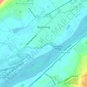
Nombre: Mapa topográfico Wyoming, altitud, relieve.
Lugar: Wyoming, Luzerne County, Pennsylvania, United States (41.29455 -75.86141 41.31773 -75.82214)
Altitud media: 174 m
Altitud mínima: 159 m
Altitud máxima: 270 m
Gracias por apoyar a este sitio ❤️
Haz una donación
Haz una donación