
Mapa topográfico Salem
Mapa interactivo
Haga clic en el mapa para ver la altitud.
Acerca de este mapa
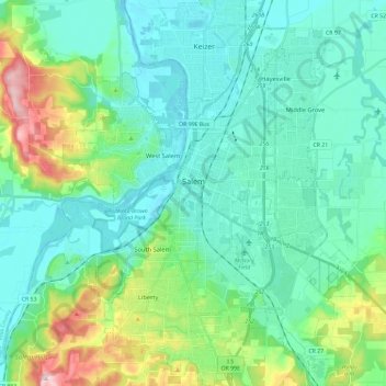
Nombre: Mapa topográfico Salem, altitud, relieve.
Lugar: Salem, Marion County, Oregon, United States (44.85125 -123.12296 45.01662 -122.93521)
Altitud media: 96 m
Altitud mínima: 30 m
Altitud máxima: 344 m
Elevation within the city limits ranges from about 120 to 800 feet (37 to 244 m). Salem contains the volcanic Salem Hills in the south and is sandwiched by the 1,000 ft (300 m) Eola Hills directly to the west and the 600 ft (180 m) Waldo Hills to the east. Northern and eastern Salem are less hilly. South and West Salem contain some canyons and are the hilliest areas. The coast range and the Cascades—including Mount Hood, Mount Jefferson, and on the clearest of days, Mount St. Helens and Mount Adams in Washington—can be viewed from throughout the city.
Otros mapas topográficos
Haga clic en un mapa para ver su topografía, su altitud y su relieve.
Aurora
United States > Oregon > Marion County
Aurora, Marion County, Oregon, United States
Altitud media: 43 m
Silverton
United States > Oregon > Marion County
Silverton, Marion County, Oregon, 97381, United States
Altitud media: 103 m
Butteville
United States > Oregon > Marion County > Butteville
Butteville, Marion County, Oregon, United States
Altitud media: 53 m
Sam Brown Creek
United States > Oregon > Marion County
Sam Brown Creek, Marion County, Oregon, 97026, United States
Altitud media: 49 m