
Gracias por apoyar a este sitio ❤️
Haz una donación
Haz una donación
Mapa topográfico South-West Oxford
Haga clic en el mapa para ver la altitud.
Gracias por apoyar a este sitio ❤️
Haz una donación
Haz una donación
South-West Oxford
In its wilderness state, the former Dereham township had thousands of acres of swamp and marsh land which limited its use for agriculture. Several large drainage projects brought great improvement and remain as essential parts of the township's farmland infrastructure. The township topography still has several large forested areas which are remnants of the original swamps on which drainage system runoff is concentrated.
Gracias por apoyar a este sitio ❤️
Haz una donación
Haz una donación
Acerca de este mapa
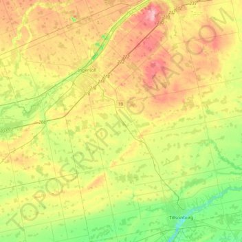
Nombre: Mapa topográfico South-West Oxford, altitud, relieve.
Altitud media: 281 m
Altitud mínima: 201 m
Altitud máxima: 388 m
Gracias por apoyar a este sitio ❤️
Haz una donación
Haz una donación
Otros mapas topográficos
Haga clic en un mapa para ver su topografía, su altitud y su relieve.