
Mapa topográfico Lago Yulton
Mapa interactivo
Haga clic en el mapa para ver la altitud.
Acerca de este mapa
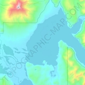
Nombre: Mapa topográfico Lago Yulton, altitud, relieve.
Altitud media: 676 m
Altitud mínima: 476 m
Altitud máxima: 2,102 m
Otros mapas topográficos
Haga clic en un mapa para ver su topografía, su altitud y su relieve.
Canal Moraleda
Chile > Región Aysén del General Carlos Ibáñez del Campo > Aysén > Estero Copa
Canal Moraleda, Manuel Rodríguez, Estero Copa, Aysén, Provincia de Aysén, Región Aysén del General Carlos Ibáñez del Campo, Chile
Altitud media: 276 m
Isla Kent
Chile > Región Aysén del General Carlos Ibáñez del Campo > Aysén
Isla Kent, Aysén, Provincia de Aysén, Región Aysén del General Carlos Ibáñez del Campo, Chile
Altitud media: 53 m
Reserva Nacional Las Guaitecas
Chile > Región Aysén del General Carlos Ibáñez del Campo > Aysén
Reserva Nacional Las Guaitecas, Aysén, Provincia de Aysén, Región Aysén del General Carlos Ibáñez del Campo, Chile
Altitud media: 155 m
Isla Nalcayec
Chile > Región Aysén del General Carlos Ibáñez del Campo > Aysén
Isla Nalcayec, Aysén, Provincia de Aysén, Región Aysén del General Carlos Ibáñez del Campo, Chile
Altitud media: 241 m
Península de Taitao
Chile > Región Aysén del General Carlos Ibáñez del Campo > Aysén
Península de Taitao, Aysén, Provincia de Aysén, Región Aysén del General Carlos Ibáñez del Campo, Chile
Altitud media: 616 m
Isla Quillín
Chile > Región Aysén del General Carlos Ibáñez del Campo > Aysén
Isla Quillín, Aysén, Provincia de Aysén, Región Aysén del General Carlos Ibáñez del Campo, Chile
Altitud media: 4 m
Monte San Valentín
Chile > Región Aysén del General Carlos Ibáñez del Campo > Aysén
Monte San Valentín, Aysén, Provincia de Aysén, Región Aysén del General Carlos Ibáñez del Campo, Chile
Altitud media: 3,353 m
Lago Presidente Ríos
Chile > Región Aysén del General Carlos Ibáñez del Campo > Aysén
Lago Presidente Ríos, Aysén, Provincia de Aysén, Región Aysén del General Carlos Ibáñez del Campo, Chile
Altitud media: 224 m
Isla Isquiliac
Chile > Región Aysén del General Carlos Ibáñez del Campo > Aysén
Isla Isquiliac, Aysén, Provincia de Aysén, Región Aysén del General Carlos Ibáñez del Campo, Chile
Altitud media: 167 m
Isla Melchor
Chile > Región Aysén del General Carlos Ibáñez del Campo > Aysén
Isla Melchor, Aysén, Provincia de Aysén, Región Aysén del General Carlos Ibáñez del Campo, Chile
Altitud media: 179 m
Isla Clemente
Chile > Región Aysén del General Carlos Ibáñez del Campo > Aysén
Isla Clemente, Aysén, Provincia de Aysén, Región Aysén del General Carlos Ibáñez del Campo, Chile
Altitud media: 144 m
Isla Quemada
Chile > Región Aysén del General Carlos Ibáñez del Campo > Aysén
Isla Quemada, Aysén, Provincia de Aysén, Región Aysén del General Carlos Ibáñez del Campo, Chile
Altitud media: 165 m
Glaciar San Quintín
Chile > Región Aysén del General Carlos Ibáñez del Campo > Aysén
Glaciar San Quintín, Aysén, Provincia de Aysén, Región Aysén del General Carlos Ibáñez del Campo, Chile
Altitud media: 526 m
Isla Garrido
Chile > Región Aysén del General Carlos Ibáñez del Campo > Aysén
Isla Garrido, Aysén, Provincia de Aysén, Región Aysén del General Carlos Ibáñez del Campo, Chile
Altitud media: 157 m
Isla Dring
Chile > Región Aysén del General Carlos Ibáñez del Campo > Aysén
Isla Dring, Aysén, Provincia de Aysén, Región Aysén del General Carlos Ibáñez del Campo, Chile
Altitud media: 161 m
Isla Luz
Chile > Región Aysén del General Carlos Ibáñez del Campo > Aysén
Isla Luz, Aysén, Provincia de Aysén, Región Aysén del General Carlos Ibáñez del Campo, Chile
Altitud media: 135 m
Isla Rivero
Chile > Región Aysén del General Carlos Ibáñez del Campo > Aysén
Isla Rivero, Aysén, Provincia de Aysén, Región Aysén del General Carlos Ibáñez del Campo, Chile
Altitud media: 159 m
Isla Salas
Chile > Región Aysén del General Carlos Ibáñez del Campo > Aysén
Isla Salas, Aysén, Provincia de Aysén, Región Aysén del General Carlos Ibáñez del Campo, Chile
Altitud media: 144 m