
Mapa topográfico Vigan
Haga clic en el mapa para ver la altitud.
Vigan
Vigan is situated in a Quaternary Age sedimentary plain called the Vigan-Bantay Plain which is part of the Ilocos coastal plain. The Vigan-Bantay Plain is bounded on the east by a moderately rugged Miocene sediments consisting of interbedded sandstones and shale to very rugged Meta-volcanics and Meta sediment topography; on the south is the Municipality of Santa where the north–south trending fault terminates; to the west is the South China Sea; while the northern boundary opens to the northern extension of the Ilocos coastal plain.
Acerca de este mapa
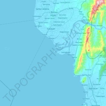
Nombre: Mapa topográfico Vigan, altitud, relieve.
Lugar: Vigan, Ilocos Sur, Ilocos Region, 2700, Philippines (17.39422 120.20346 17.59134 120.43231)
Altitud media: 33 m
Altitud mínima: -1 m
Altitud máxima: 748 m
Otros mapas topográficos
Haga clic en un mapa para ver su topografía, su altitud y su relieve.
Vigan
Vigan is situated in a Quaternary Age sedimentary plain called the Vigan-Bantay Plain which is part of the Ilocos coastal plain. The Vigan-Bantay Plain is bounded on the east by a moderately rugged Miocene sediments consisting of interbedded sandstones and shale to very rugged Meta-volcanics and Meta sediment…
Altitud media: 63 m
Santa
The topography of the municipality is undulating to rolling with slope ranging from 0-30%.
Altitud media: 75 m
Bantay
It has an average elevation of 100 meters (328.08 feet), with a land area of 7,660 hectares (18,900 acres). It is an elevated and hilly municipality but some barangays, especially those near creeks, are prone to flooding during heavy typhoons.
Altitud media: 8 m
Candon
Philippines > Ilocos Sur > Candon
Candon City is situated in the lower central portion of the Province of Ilocos Sur. It has a "C" shape with elevations ranging from 10 – 500 ft above sea level. The city is 346 kilometres (215 mi) from Metro Manila and 61 kilometres (38 mi) from Vigan City, the provincial capital.
Altitud media: 108 m