
Mapa topográfico De Smet
Mapa interactivo
Haga clic en el mapa para ver la altitud.
De Smet
U.S. Route 95 passes nearby and the community is located about a mile (1.6 km) south of Tensed, which was originally also to be titled Desmet before the name was ordered to be reversed and was subsequently misspelled by the post office. Latah Creek flows between the two communities. De Smet has a post office with a ZIP code of 83824. As of the 2010 census, its population was 145, and its elevation is approximately 2,600 feet (790 m) above sea level.
Acerca de este mapa
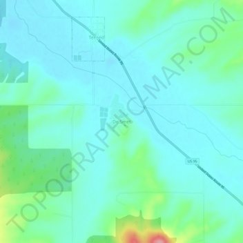
Nombre: Mapa topográfico De Smet, altitud, relieve.
Lugar: De Smet, Benewah County, Idaho, 83824, United States (47.12601 -116.93572 47.16601 -116.89572)
Altitud media: 794 m
Altitud mínima: 771 m
Altitud máxima: 894 m
Otros mapas topográficos
Haga clic en un mapa para ver su topografía, su altitud y su relieve.
Tensed
United States > Idaho > Benewah County
Tensed is located at 47°9′37″N 116°55′27″W / 47.16028°N 116.92417°W / 47.16028; -116.92417 (47.160284, -116.924304), at an elevation of 2,562 feet (781 m) above sea level.
Altitud media: 785 m