
Haz una donación
Mapa topográfico San Jose
Haga clic en el mapa para ver la altitud.
Haz una donación
San Jose
The municipality is in a valley bounded on the east by the Palusong Mountain Range moving south and on the west by the Hitaasan Mountain Range. The land is generally alluvial flat and swamplands which has an elevation of less than 10 metres (33 ft) above sea level, while going south, south easterly, the physiography abruptly rises to moderately rugged hills with a peak of 68 metres (223 ft). The drainage system in the area generally flows north-east towards Carangian Channel. Vegetation in this area generally consists of mangrove trees and shrubs, cogonal growth, and coconuts. The flat areas are planted with rice, corn and coconuts.
Haz una donación
Acerca de este mapa
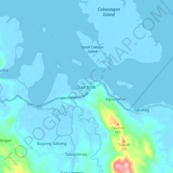
Nombre: Mapa topográfico San Jose, altitud, relieve.
Lugar: San Jose, Northern Samar, Eastern Visayas, 6402, Philippines (12.49019 124.44785 12.57019 124.52785)
Altitud media: 15 m
Altitud mínima: -3 m
Altitud máxima: 251 m
Haz una donación
Otros mapas topográficos
Haga clic en un mapa para ver su topografía, su altitud y su relieve.
Haz una donación
Haz una donación
Haz una donación