Geolocalizar

Mapa topográfico Dharavi

Haga clic en el mapa para ver la altitud.

Acerca de este mapa

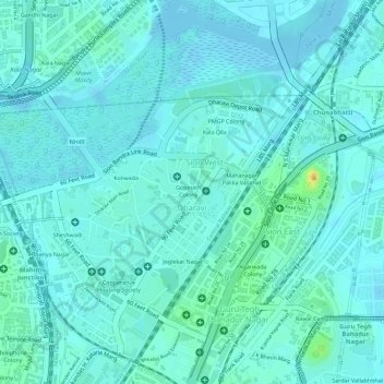
Nombre: Mapa topográfico Dharavi, altitud, relieve.

Lugar: Dharavi, Mumbai Zone 2, Mumbai City District, Maharashtra, India (19.03688 72.84842 19.05423 72.86513)

Altitud media: 6 m

Altitud mínima: -4 m

Altitud máxima: 32 m

Otros mapas topográficos

Haga clic en un mapa para ver su topografía, su altitud y su relieve.

Mumbai

India > Maharashtra > Mumbai

Mumbai is on a narrow peninsula on the southwest of Salsette Island, which lies between the Arabian Sea to the west, Thane Creek to the east and Vasai Creek to the north. Mumbai's suburban district occupies most of the island. Navi Mumbai is east of Thane Creek and Thane is north of Vasai Creek. Mumbai…

Altitud media: 18 m

Pune

India > Maharashtra > Pune City Subdistrict

Altitud media: 641 m

Sanjay Gandhi National Park

India > Maharashtra > Thane Taluka > Thane

The region is hilly with elevations between 30 and 480 m (98 and 1,575 ft). Vihar Lake and Tulsi Lake in the park meet a part of the city's water requirements. The park is said to be the lungs of the city as it purifies much of the air pollution in the city.

Altitud media: 42 m

Mumbai

India > Maharashtra

Mumbai lies at the mouth of the Ulhas River on the western coast of India, in the coastal region known as the Konkan. It sits on Salsette Island (Sashti Island), which it partially shares with the Thane district. Mumbai is bounded by the Arabian Sea to the west. Many parts of the city lie just above sea level,…

Altitud media: 13 m

Maharashtra

India > Maharashtra

Maharashtra is the third largest state by area in India. The Western Ghats better known as Sahyadri, are a hilly range running parallel to the coast, at an average elevation of 1,200 metres (4,000 ft). Kalsubai, a peak in the Sahyadris, near Nashik city is the highest elevated point in Maharashtra. To the west…

Altitud media: 478 m

Pune

India > Maharashtra > Pune City

Altitud media: 641 m

Navi Mumbai

India > Maharashtra > Thane > Navi Mumbai

Navi Mumbai (Marathi pronunciation: , also known by its former name New Bombay), is a planned city off the west coast of the Indian state of Maharashtra in Konkan division. The city is divided into two parts, North Navi Mumbai and South Navi Mumbai, for the individual development of Panvel Mega City, which…

Altitud media: 30 m

Parbhani

India > Maharashtra

Altitud media: 401 m

Dharashiv

India > Maharashtra

Altitud media: 640 m

Navi Mumbai

India > Maharashtra > Thane Subdistrict

Navi Mumbai (Marathi pronunciation: [nəʋiː mumbəiː]), is a planned city situated on the west coast of the Indian subcontinent, located in the Konkan division of Maharashtra state, on the mainland of India. Navi Mumbai is part of the Mumbai Metropolitan Region (MMR). The city is divided into two, North…

Altitud media: 22 m

Mandangad

India > Maharashtra > Mandangad Taluka

Altitud media: 214 m

Alibag

India > Maharashtra > Alibag Taluka

Alibag is located about 120 km south of Mumbai, at 18°38′29″N 72°52′20″E / 18.64139°N 72.87222°E / 18.64139; 72.87222. The average elevation is 0 metres (0 feet).The District Government offices are located along the sea coast road. Alibag is the center place of Raigad District.

Altitud media: 12 m

Mumbai

India > Maharashtra

Mumbai is on a narrow peninsula on the southwest of Salsette Island, which lies between the Arabian Sea to the west, Thane Creek to the east and Vasai Creek to the north. Mumbai's suburban district occupies most of the island. Navi Mumbai is east of Thane Creek and Thane is north of Vasai Creek. Mumbai…

Altitud media: 18 m

Nagpur

India > Maharashtra > Nagpur Urban Taluka

Altitud media: 307 m

Pune City

India > Maharashtra

Pune lies on the western margin of the Deccan plateau, at an altitude of 560 m (1,840 ft) above sea level. It is on the leeward side of the Sahyadri mountain range, which forms a barrier from the Arabian Sea. It is a hilly city, with Vetal Hill rising to 800 m (2,600 ft) above sea level. The Sinhagad fort is…

Altitud media: 616 m

Dindori Taluka

India > Maharashtra

Altitud media: 671 m

Buldhana District

India > Maharashtra

Lonarkar Top (about 923 meters) is highest altitude in Buldhana District placed in Ambabarwa Wildlife Sanctuary.

Altitud media: 425 m

Jalna District

India > Maharashtra

The district occupies an area of 7,718 square kilometres (2,980 sq mi). The range of geographical latitudes and longitudes of the district is from 19.01' N to 21.03'N and from 75.04'E to 76.04'E, with gently to moderately sloping topography. The Northern part of the district is occupied by the Ajanta and…

Altitud media: 542 m

Satara

India > Maharashtra

Altitud media: 677 m

Panvel

India > Maharashtra > Panvel > Panvel

Matheran is a hill station and a municipal council in the Raigad district in the Indian state of Maharashtra. It is a hill station in Karjat Tahsil and is also the smallest hill station in India. It is located on the Western Ghats range at an elevation of around 800 m (2,625 feet) above sea level. It is…

Altitud media: 75 m

Nanded District

India > Maharashtra

Nanded is bounded on the north by Yavatmal district of the Vidarbha region, with Latur on south-west, Parbhani and Hingoli districts on the west. On the eastern side lies Adilabad, Nirmal, Nizamabad and Kamareddy districts of Telangana state, and on the south lies Bidar of Karnataka state. The area presents…

Altitud media: 432 m

Latur District

India > Maharashtra

Latur district is in the Marathwada region in Maharashtra in India, located between 17°52' North to 18°50' North and 76°18' East to 79°12' East in the Deccan plateau. It has an average elevation of 631 metres (2,070 ft) above mean sea level. The entire district of Latur is on the Balaghat plateau, 540 to…

Altitud media: 590 m

Belapur Fort

India > Maharashtra > Thane > Navi Mumbai

Altitud media: 5 m

Pandharpur

India > Maharashtra

Altitud media: 485 m

Pune

India > Maharashtra

Pune is situated at approximately 18° 32" north latitude and 73° 51" east longitude. The city's total area is 15.642 km2, and the municipal corporation area covers 518 km2. By road Pune is 149 km (93 mi) south-east of Mumbai, 580 km (360 mi) south-west of Indore, 695 km (432 mi) west of Nagpur, 1,173 km (729…

Altitud media: 616 m

Amravati

India > Maharashtra

Altitud media: 349 m

Ahmednagar District

India > Maharashtra

Altitud media: 596 m

Jalgaon

India > Maharashtra

Altitud media: 360 m

Raigad

India > Maharashtra

Altitud media: 237 m

Mumbai

India > Maharashtra

Altitud media: 25 m

Khalapur Taluka

India > Maharashtra

Altitud media: 191 m

Pune District

India > Maharashtra

Altitud media: 521 m

Dodamarg

India > Maharashtra

Altitud media: 291 m

Palghar

India > Maharashtra > Palghar Taluka

Altitud media: 19 m

Chandur Railway

India > Maharashtra

Chandur Railway is located at 20.8142° N, 77.9767° E . It has an average elevation of 332 metres (1089 feet).

Altitud media: 319 m

Niphad Taluka

India > Maharashtra

Altitud media: 585 m

Haveli

India > Maharashtra

Altitud media: 645 m

Yavatmal District

India > Maharashtra

Altitud media: 328 m

Solapur District

India > Maharashtra

Altitud media: 565 m

Wardha

India > Maharashtra

Altitud media: 313 m

Ambegaon

India > Maharashtra

Altitud media: 703 m

Jalgaon District

India > Maharashtra

Altitud media: 399 m

Panhala

India > Maharashtra

Panhala is located at 16°49′12″N 74°7′12″E / 16.82000°N 74.12000°E / 16.82000; 74.12000. It has an average elevation of 754 metres (2473 feet). Panhala is connected via train and bus to Kolhapur and Sangli. Kolhapur is about 21 km away while Sangli is about 60 km. Kolhapur Chhatrapati…

Altitud media: 620 m

Shahuwadi

India > Maharashtra

Altitud media: 601 m

Shahapur Taluka

India > Maharashtra

Altitud media: 224 m

Paithan

India > Maharashtra

Paithan is located at 19°29′N 75°23′E / 19.48°N 75.38°E / 19.48; 75.38. It has an average elevation of 458 m (1,503 ft).

Altitud media: 495 m

Hatkanangle

India > Maharashtra

Altitud media: 574 m

Mangrulpir

India > Maharashtra

Altitud media: 463 m

Lonar

India > Maharashtra

Altitud media: 541 m

Washim

India > Maharashtra

Altitud media: 413 m

Bhor

India > Maharashtra

Altitud media: 763 m

Nashik District

India > Maharashtra

The entire Nashik district is underlain by the basaltic lava flows. These flows are normally horizontally disposed over a wide stretch and give rise to table land type of topography also known as a plateau. These flows occur in layered sequences and represented by massive unit at the bottom and vesicular unit…

Altitud media: 522 m

Aundha (Nagnath)

India > Maharashtra

Altitud media: 445 m

Akrani Taluka

India > Maharashtra

Altitud media: 426 m

Rahuri

India > Maharashtra

Altitud media: 563 m

Shevgaon

India > Maharashtra

Altitud media: 493 m

Akola District

India > Maharashtra

Akola district lies in the northern plains of the Deccan Plateau. Akola district covers mostly plain topology with isolated hills and mounds except for the mountain ranges of Ajintha (Ajanta), located in the Southern tehsils of Patur and Barshi Takli, and the Satpuda mountain range that occupies some areas in…

Altitud media: 340 m

Chandrapur

India > Maharashtra

Altitud media: 243 m

Gadchiroli

India > Maharashtra

Altitud media: 296 m

Nashik

India > Maharashtra

Altitud media: 555 m

Palghar

India > Maharashtra

Altitud media: 160 m

Malshiras

India > Maharashtra

Altitud media: 551 m

Goregaon

India > Maharashtra

Altitud media: 324 m

Mulshi

India > Maharashtra

Altitud media: 657 m

Khandala

India > Maharashtra

Altitud media: 707 m

Sudhagad Taluka

India > Maharashtra

Altitud media: 222 m

Nagpur

India > Maharashtra

Nagpur is located at the exact centre of the Indian subcontinent, close to the geometric centre of the quadrilateral connecting the four major metros of India, viz. Chennai, Mumbai, New Delhi and Kolkata. The city has the Zero Mile Stone locating the geographical centre of India, which was used by the British…

Altitud media: 309 m

Chopda

India > Maharashtra

Altitud media: 306 m

Kamptee Taluka

India > Maharashtra

Altitud media: 282 m

Jamner

India > Maharashtra

Altitud media: 348 m

Parseoni

India > Maharashtra

Altitud media: 352 m

Khanapur

India > Maharashtra

Altitud media: 702 m

Akola

India > Maharashtra

Altitud media: 292 m

Thane

India > Maharashtra > Thane Taluka

Altitud media: 54 m

Jalna

India > Maharashtra

Altitud media: 514 m

Radhanagari

India > Maharashtra

Altitud media: 569 m

Solapur South

India > Maharashtra

Altitud media: 473 m

Khatav

India > Maharashtra

Altitud media: 757 m

Chandurbazar

India > Maharashtra

Altitud media: 394 m

Kolhapur District

India > Maharashtra

Kolhapur experiences winter from November to February. The winter temperatures are warmer than other cities in Maharashtra such as Pune and Nashik. Lows range from 9 to 16 °C (48 to 61 °F) while highs are in the range of 24 to 32 °C (75 to 90 °F) due to its high elevation and being adjacent to the Western…

Altitud media: 464 m

Chikhaldara

India > Maharashtra

The sole hill resort in the Vidarbha region, it is situated at an altitude of 1118 meters with highest elevation point 1188 meters and has the added dimension of being the only coffee-growing area in Maharashtra. Chikhaldara has an annual rainfall of 154cm. Temperatures vary from 39C in summer to 5C in winter.…

Altitud media: 521 m

Purandhar

India > Maharashtra

Altitud media: 694 m

Akkalkuwa Taluka

India > Maharashtra

Altitud media: 393 m

Ambejogai

India > Maharashtra

Altitud media: 604 m

Shirol

India > Maharashtra

Altitud media: 555 m

Akkalkot

India > Maharashtra

Altitud media: 478 m

Loni Kalbhor

India > Maharashtra > Haveli

Altitud media: 546 m

Mumbai

India > Maharashtra

Mumbai lies at the mouth of the Ulhas River on the western coast of India, in the coastal region known as the Konkan. It sits on Salsette Island (Sashti Island), which it partially shares with the Thane district. Mumbai is bounded by the Arabian Sea to the west. Many parts of the city lie just above sea level,…

Altitud media: 13 m

Karjat

India > Maharashtra > Karjat Taluka

Altitud media: 109 m

Ichalkaranji

India > Maharashtra > Hatkanangle

Ichalkaranji is located at 16°42′N 74°28′E / 16.7°N 74.47°E / 16.7; 74.47. It has an average elevation of 538 metres (1,765 ft).

Altitud media: 562 m

Antop Hill

India > Maharashtra > Mumbai

Altitud media: 6 m

Washi

India > Maharashtra

Altitud media: 688 m

Ratnagiri

India > Maharashtra

An outstanding feature of the geography of the district is its uneven or hill topography, with about 45% of the district being characterized as 'hilly'. Very narrow riverine plains fringe the coastline.

Altitud media: 301 m

Solapur

India > Maharashtra > Solapur North

Solapur is located at 17°41′N 75°55′E / 17.68°N 75.92°E / 17.68; 75.92. It has an average elevation of 458 metres (1502 feet). It is bordered by Ahmednagar district on the north; Osmanabad district on the north and northeast.

Altitud media: 469 m

Thane

India > Maharashtra > Thane Taluka

Altitud media: 54 m

Mhalunge

India > Maharashtra

Altitud media: 780 m

Lonavala

India > Maharashtra > Mawal

Adjacent to the Lohagad fort lies the visapur fort which is part of the Lohagad-Visapur fortification. Visapur Fort is larger and at a higher elevation than its twin- Lohagad. It was built during 1713-1720 CE by Balaji Vishwanath.

Altitud media: 613 m

Ahmadnagar

India > Maharashtra

Altitud media: 596 m

Sindhudurg

India > Maharashtra

Altitud media: 202 m