
Mapa topográfico Gallup
Mapa interactivo
Haga clic en el mapa para ver la altitud.
Acerca de este mapa
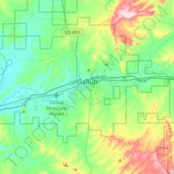
Nombre: Mapa topográfico Gallup, altitud, relieve.
Lugar: Gallup, McKinley County, New Mexico, 87301, United States (35.49099 -108.84735 35.55211 -108.59959)
Altitud media: 2,067 m
Altitud mínima: 1,946 m
Altitud máxima: 2,401 m
Gallup, like most of the interior Mountain West, has a cool semiarid climate (Köppen BSk). The summers are hot during the day, but the high altitude and low humidity mean that nights remain distinctly cool; as late as July 2, 1997, the temperature fell to 31 °F (−1 °C). Despite the large diurnal temperature range, most rain falls in the summer from afternoon thunderstorms. Snow is common and sometimes heavy; the maximum in a month is 29.10 inches (0.74 m) in December 1992 and the most in a year 65.10 inches (1.65 m) between July 1990 and June 1991. Actual snow cover, with the hot sun at Gallup's altitude, however, has never exceeded 13.1 inches (0.33 m), and for no day averages over 3.5 inches (0.089 m).
Otros mapas topográficos
Haga clic en un mapa para ver su topografía, su altitud y su relieve.
Zuni Pueblo
United States > New Mexico > McKinley County
Zuni Pueblo, McKinley County, New Mexico, 87327, United States
Altitud media: 1,931 m
Littlewater
United States > New Mexico > McKinley County
Littlewater, Eastern Navajo Agency, McKinley County, New Mexico, United States
Altitud media: 2,082 m
Crownpoint
United States > New Mexico > McKinley County
Crownpoint, Eastern Navajo Agency, McKinley County, New Mexico, 87313, United States
Altitud media: 2,099 m
Thoreau
United States > New Mexico > McKinley County
Thoreau, McKinley County, New Mexico, 87323, United States
Altitud media: 2,253 m
Pinedale
United States > New Mexico > McKinley County
Pinedale, Eastern Navajo Agency, McKinley County, New Mexico, United States
Altitud media: 2,154 m
Navajo
United States > New Mexico > McKinley County
Navajo, Fort Defiance Agency, McKinley County, New Mexico, 87328, United States
Altitud media: 2,203 m
Prewitt Lake
United States > New Mexico > McKinley County
Prewitt Lake, McKinley County, New Mexico, United States
Altitud media: 2,393 m
Nahodishgish
United States > New Mexico > McKinley County
Nahodishgish, Eastern Navajo Agency, McKinley County, New Mexico, United States
Altitud media: 2,061 m
Continental Divide
United States > New Mexico > McKinley County
Continental Divide, McKinley County, New Mexico, 87312, United States
Altitud media: 2,221 m
Ramah
United States > New Mexico > McKinley County
Ramah, Eastern Navajo Agency, McKinley County, New Mexico, United States
Altitud media: 2,184 m
Eastern Navajo Agency
United States > New Mexico > McKinley County
Eastern Navajo Agency, McKinley County, New Mexico, United States
Altitud media: 2,005 m
Pueblo Pintado
United States > New Mexico > McKinley County > Pueblo Pintado
Pueblo Pintado, Navajo Route 7008, Pueblo Pintado, Eastern Navajo Agency, McKinley County, New Mexico, United States
Altitud media: 1,981 m
Smith Lake
United States > New Mexico > McKinley County
Smith Lake, Eastern Navajo Agency, McKinley County, New Mexico, United States
Altitud media: 2,221 m
Tinian
United States > New Mexico > McKinley County
Tinian, Eastern Navajo Agency, McKinley County, New Mexico, United States
Altitud media: 2,014 m