
Mapa topográfico Ashmore Pond
Mapa interactivo
Haga clic en el mapa para ver la altitud.
Acerca de este mapa
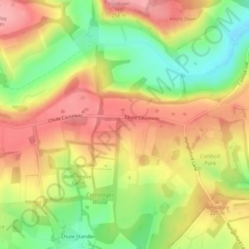
Nombre: Mapa topográfico Ashmore Pond, altitud, relieve.
Lugar: Ashmore Pond, Chute, Wiltshire, England, United Kingdom (51.29449 -1.55031 51.29469 -1.55002)
Altitud media: 205 m
Altitud mínima: 138 m
Altitud máxima: 261 m
Otros mapas topográficos
Haga clic en un mapa para ver su topografía, su altitud y su relieve.
Little Down
United Kingdom > England > Wiltshire > Chute
Little Down, Chute, Wiltshire, England, SN8 3NW, United Kingdom
Altitud media: 211 m