
Mapa topográfico Benhaan
Haga clic en el mapa para ver la altitud.
Acerca de este mapa
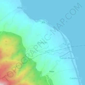
Nombre: Mapa topográfico Benhaan, altitud, relieve.
Altitud media: 125 m
Altitud mínima: -1 m
Altitud máxima: 742 m
Otros mapas topográficos
Haga clic en un mapa para ver su topografía, su altitud y su relieve.
Camiguin
Philippines > Camiguin > Mambajao
Camiguin Island is a pearl-shaped island with an area of approximately 238 km2 (92 sq mi). The island measures about 23 kilometres (14 mi) at its longest and 14.5 kilometres (9.0 mi) at its widest breadth. The island is mountainous with the highest elevation reaching over 5,000 ft (1,500 m). It is encircled by…
Altitud media: 207 m