
Mapa topográfico Ashland
Mapa interactivo
Haga clic en el mapa para ver la altitud.
Acerca de este mapa
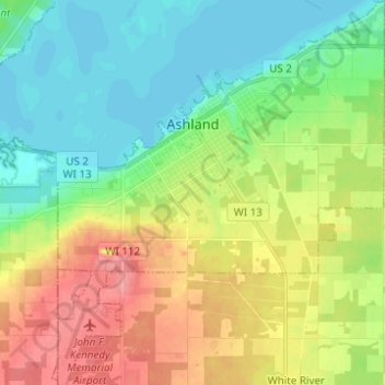
Nombre: Mapa topográfico Ashland, altitud, relieve.
Lugar: Ashland, Ashland County, Wisconsin, United States (46.53465 -90.92912 46.61951 -90.82231)
Altitud media: 209 m
Altitud mínima: 179 m
Altitud máxima: 256 m
Otros mapas topográficos
Haga clic en un mapa para ver su topografía, su altitud y su relieve.
Glidden
United States > Wisconsin > Ashland County
Glidden, Town of Jacobs, Ashland County, Wisconsin, 54527, United States
Altitud media: 468 m
Madeline Island
United States > Wisconsin > Ashland County > La Pointe
Madeline Island, La Pointe, Town of La Pointe, Ashland County, Wisconsin, 54580, United States
Altitud media: 187 m
Mellen
United States > Wisconsin > Ashland County
Mellen, Ashland County, Wisconsin, 54546, United States
Altitud media: 395 m
Highbridge
United States > Wisconsin > Ashland County
Highbridge, Town of Ashland, Ashland County, Wisconsin, 54846, United States
Altitud media: 295 m
Clam Lake
United States > Wisconsin > Ashland County
Clam Lake, Town of Gordon, Ashland County, Wisconsin, United States
Altitud media: 441 m
La Pointe
United States > Wisconsin > Ashland County
La Pointe, Town of La Pointe, Ashland County, Wisconsin, 54580, United States
Altitud media: 186 m
Butternut
United States > Wisconsin > Ashland County
Butternut, Ashland County, Wisconsin, United States
Altitud media: 466 m
Marengo
United States > Wisconsin > Ashland County
Marengo, Town of White River, Ashland County, Wisconsin, 54855, United States
Altitud media: 240 m
Pictured Rock Lake
United States > Wisconsin > Ashland County
Pictured Rock Lake, Town of Sanborn, Ashland County, Wisconsin, United States
Altitud media: 199 m
Town of Sanborn
United States > Wisconsin > Ashland County
Town of Sanborn, Ashland County, Wisconsin, 54861, United States
Altitud media: 220 m
Town of Chippewa
United States > Wisconsin > Ashland County
Town of Chippewa, Ashland County, Wisconsin, 54671, United States
Altitud media: 458 m