
Mapa topográfico Upper Wield
Haga clic en el mapa para ver la altitud.
Acerca de este mapa
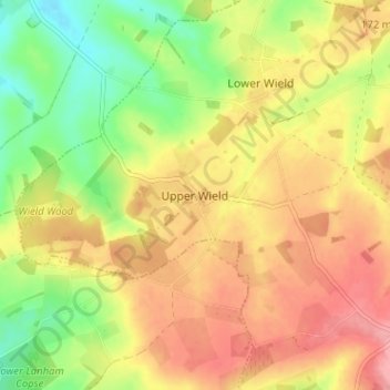
Nombre: Mapa topográfico Upper Wield, altitud, relieve.
Altitud media: 158 m
Altitud mínima: 106 m
Altitud máxima: 203 m
Otros mapas topográficos
Haga clic en un mapa para ver su topografía, su altitud y su relieve.
Rowland's Copse, Red Hill
United Kingdom > England > Hampshire > East Hampshire > Rowlands Castle
Altitud media: 42 m
Newton Valence
United Kingdom > England > Hampshire > East Hampshire
The village sits high in the westernmost chalk hills of the South Downs: maximum elevation 191 metres (627 feet) above sea level. Much of the surrounding landscape is within the East Hampshire Area of Outstanding Natural Beauty.
Altitud media: 153 m
Bramshott Common
United Kingdom > England > Hampshire > East Hampshire > Bramshott
Altitud media: 148 m
Havant Thicket
United Kingdom > England > Hampshire > East Hampshire > Rowlands Castle
Altitud media: 48 m
Ludshott Common
United Kingdom > England > Hampshire > East Hampshire > Bramshott
Altitud media: 162 m
Farringdon
United Kingdom > England > Hampshire > East Hampshire > Lower Farringdon
Altitud media: 153 m
Shalden
United Kingdom > England > Hampshire > East Hampshire
Shalden is a village and civil parish in the East Hampshire district of Hampshire, England. It is 2.3 miles (3.7 km) northwest of Alton and 1.9 miles (3.1 km) northeast of Bentworth, just off the A339 road. The parish covers an area of 1,536 acres (622 ha) and has an average elevation of 600 feet (180 m) above…
Altitud media: 177 m
Queen Elizabeth Country Park
United Kingdom > England > Hampshire > East Hampshire > Buriton
Altitud media: 151 m
Medstead
United Kingdom > England > Hampshire > East Hampshire
Medstead is a village and civil parish in the East Hampshire district of Hampshire, England. Its nearest town is Alton, which lies 4.3 miles (6.9 km) northeast of the village. According to the 2011 census, the village had a population of 2,036 people. The parish covers an area of 1,536 acres (622 ha) and has…
Altitud media: 186 m
Lasham
United Kingdom > England > Hampshire > East Hampshire
The parish covers an area of 1,797 acres (727 ha) and has an average elevation of 560 feet (170 m) above sea level. The nearest railway station is Alton, 3.5 miles (5.6 km) southeast of the village. Lasham formerly had its own railway station, Bentworth and Lasham, on the Basingstoke and Alton Light Railway…
Altitud media: 168 m
Medstead
United Kingdom > England > Hampshire > East Hampshire
Medstead is a village and civil parish in the East Hampshire district of Hampshire, England. Its nearest town is Alton, which lies 4.3 miles (6.9 km) northeast of the village. According to the 2011 census, the village had a population of 2,036 people. The parish covers an area of 1,536 acres (622 ha) and has…
Altitud media: 186 m