
Mapa topográfico San Angelo
Mapa interactivo
Haga clic en el mapa para ver la altitud.
Acerca de este mapa
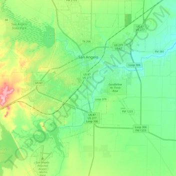
Nombre: Mapa topográfico San Angelo, altitud, relieve.
Lugar: San Angelo, Tom Green County, Texas, United States (31.33550 -100.52929 31.52649 -100.35993)
Altitud media: 576 m
Altitud mínima: 536 m
Altitud máxima: 672 m
Otros mapas topográficos
Haga clic en un mapa para ver su topografía, su altitud y su relieve.
San Angelo
United States > Texas > Tom Green County > San Angelo
San Angelo, Tom Green County, Texas, 76903, United States
Altitud media: 588 m
Grape Creek
United States > Texas > Tom Green County > Grape Creek
Grape Creek, Tom Green County, Texas, United States
Altitud media: 609 m