
Mapa topográfico Lee Valley
Mapa interactivo
Haga clic en el mapa para ver la altitud.
Acerca de este mapa
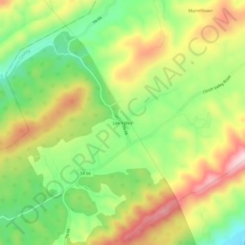
Nombre: Mapa topográfico Lee Valley, altitud, relieve.
Lugar: Lee Valley, Hawkins County, Tennessee, United States (36.44315 -83.16350 36.48315 -83.12350)
Altitud media: 531 m
Altitud mínima: 380 m
Altitud máxima: 709 m
Otros mapas topográficos
Haga clic en un mapa para ver su topografía, su altitud y su relieve.
Greenland
United States > Tennessee > Hawkins County > Church Hill
Greenland, Church Hill, Hawkins County, East Tennessee, Tennessee, United States
Altitud media: 379 m
Eidson
United States > Tennessee > Hawkins County
Eidson, Hawkins County, East Tennessee, Tennessee, 37731, United States
Altitud media: 526 m
Surgoinsville
United States > Tennessee > Hawkins County
Surgoinsville, Hawkins County, East Tennessee, Tennessee, United States
Altitud media: 407 m
Church Hill
United States > Tennessee > Hawkins County > Church Hill
Church Hill, Hawkins County, Tennessee, 37642, United States
Altitud media: 463 m