
Mapa topográfico Kolkata
Mapa interactivo
Haga clic en el mapa para ver la altitud.
Acerca de este mapa
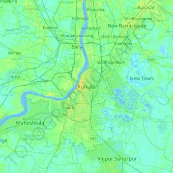
Nombre: Mapa topográfico Kolkata, altitud, relieve.
Lugar: Kolkata, Kolkata District, West Bengal, 700073, India (22.41265 88.20390 22.73265 88.52390)
Altitud media: 5 m
Altitud mínima: -2 m
Altitud máxima: 21 m
Spread roughly north–south along the east bank of the Hooghly River, Kolkata sits within the lower Ganges Delta of eastern India approximately 75 km (47 mi) west of the international border with Bangladesh; the city's elevation is 1.5–9 m (5–30 ft). Much of the city was originally a wetland that was reclaimed over the decades to accommodate a burgeoning population. The remaining undeveloped areas, known as the East Kolkata Wetlands, were designated a "wetland of international importance" by the Ramsar Convention (1975). As with most of the Indo-Gangetic Plain, the soil and water are predominantly alluvial in origin. Kolkata is located over the "Bengal basin", a pericratonic tertiary basin. Bengal basin comprises three structural units: shelf or platform in the west; central hinge or shelf/slope break; and deep basinal part in the east and southeast. Kolkata is located atop the western part of the hinge zone which is about 25 km (16 mi) wide at a depth of about 45,000 m (148,000 ft) below the surface. The shelf and hinge zones have many faults, among them some are active. Total thickness of sediment below Kolkata is nearly 7,500 m (24,600 ft) above the crystalline basement; of these the top 350–450 m (1,150–1,480 ft) is Quaternary, followed by 4,500–5,500 m (14,760–18,040 ft) of Tertiary sediments, 500–700 m (1,640–2,300 ft) trap wash of Cretaceous trap and 600–800 m (1,970–2,620 ft) Permian-Carboniferous Gondwana rocks. The quaternary sediments consist of clay, silt, and several grades of sand and gravel. These sediments are sandwiched between two clay beds: the lower one at a depth of 250–650 m (820–2,130 ft); the upper one 10–40 m (30–130 ft) in thickness. According to the Bureau of Indian Standards, on a scale ranging from I to V in order of increasing susceptibility to earthquakes, the city lies inside seismic zone III.
Otros mapas topográficos
Haga clic en un mapa para ver su topografía, su altitud y su relieve.
Raina - I
Raina - I, Purba Bardhaman District, West Bengal, India
Altitud media: 28 m
B-17
India > West Bengal > Kalyani
B-17, Kalyani, Nadia District, West Bengal, India
Altitud media: 10 m
Sillery Gaon
India > West Bengal > Kalimpong - II
Sillery Gaon, Kalimpong - II, Kalimpong District, West Bengal, 734311, India
Altitud media: 1,549 m
Kalimpong -I
Kalimpong -I, Kalimpong District, West Bengal, India
Altitud media: 824 m
New Barrackpore
India > West Bengal > Barrackpore
New Barrackpore, Barrackpore, North 24 Parganas District, West Bengal, 700131, India
Altitud media: 6 m
Kestopur Khal
India > West Bengal > Bhangar - II > Bidhannagar
Kestopur Khal, Bidhannagar, Bhangar - II, South 24 Parganas District, West Bengal, India
Altitud media: 4 m
Todey
India > West Bengal > Gorubathan
Todey, Gorubathan, Kalimpong District, West Bengal, India
Altitud media: 1,325 m
Jorebunglow Sukiapokhri
Jorebunglow Sukiapokhri, Darjeeling District, West Bengal, India
Altitud media: 1,591 m
Sonada
India > West Bengal > Jorebunglow Sukiapokhri
Sonada, Jorebunglow Sukiapokhri, Darjeeling District, West Bengal, 734102, India
Altitud media: 1,797 m
Kurseong
India > West Bengal > Kurseong Subdivision
Kurseong, Kurseong Subdivision, Darjeeling District, West Bengal, 734203, India
Altitud media: 1,127 m
Thakurpukur Maheshtala
Thakurpukur Maheshtala, South 24 Parganas District, West Bengal, India
Altitud media: 5 m
Magrahat - I
Magrahat - I, South 24 Parganas District, West Bengal, India
Altitud media: 4 m
Alipore Zoo
India > West Bengal > Kolkata
Alipore Zoo, Alipore, Kolkata, Kolkata District, West Bengal, India
Altitud media: 9 m
Alipurduar - II
Alipurduar - II, Alipurduar District, West Bengal, India
Altitud media: 57 m
Mahadipur
India > West Bengal > English Bazar
Mahadipur, English Bazar, Maldah District, West Bengal, 732216, India
Altitud media: 25 m
Madaripur
India > West Bengal > Islampur
Madaripur, Islampur, Uttar Dinajpur District, West Bengal, India
Altitud media: 69 m
Maynaguri
India > West Bengal > Maynaguri
Maynaguri, Jalpaiguri District, West Bengal, 735224, India
Altitud media: 83 m
Uttar Dinajpur District
Uttar Dinajpur District, West Bengal, India
Altitud media: 45 m
Odlabari
India > West Bengal > Mal
Odlabari, Mal, Jalpaiguri District, West Bengal, 735222, India
Altitud media: 168 m
Chalsa
India > West Bengal > Matiali
Chalsa, Matiali, Jalpaiguri District, West Bengal, 735206, India
Altitud media: 185 m
Jaigaon
India > West Bengal > Kalchini
Jaigaon, Kalchini, Alipurduar District, West Bengal, 735182, India
Altitud media: 316 m
Tamluk
India > West Bengal > Tamluk
Tamluk, Purba Medinipur District, West Bengal, 721600, India
Altitud media: 3 m
Jamalpur
Jamalpur, Purba Bardhaman District, West Bengal, India
Altitud media: 19 m
Kranti
India > West Bengal > Mal
Kranti, Mal, Jalpaiguri District, West Bengal, 735218, India
Altitud media: 100 m
Bhangar - I
Bhangar - I, South 24 Parganas District, West Bengal, 743502, India
Altitud media: 3 m
Raninagar - II
Raninagar - II, Murshidabad District, West Bengal, 742308, India
Altitud media: 18 m
Belpahari
India > West Bengal > Binpur-II
Belpahari, Binpur-II, Jhargram District, West Bengal, India
Altitud media: 140 m
Jagatballavpur
Jagatballavpur, Howrah District, West Bengal, India
Altitud media: 5 m
Amdanga
India > West Bengal > Amdanga
Amdanga, North 24 Parganas District, West Bengal, 743221, India
Altitud media: 7 m
Kolaghat
India > West Bengal > Kolaghat
Kolaghat, Purba Medinipur District, West Bengal, 721134, India
Altitud media: 4 m
Bankura
India > West Bengal > Bankura - I
Bankura, Bankura - I, Bankura District, West Bengal, 722101, India
Altitud media: 103 m
Narayanpur,purba bardhaman,713127
India > West Bengal > Bhatar
Narayanpur,purba bardhaman,713127, Bhatar, Purba Bardhaman District, West Bengal, 713127, India
Altitud media: 36 m
West Dinājpur
West Dinājpur, Dakshin Dinajpur District, West Bengal, India
Altitud media: 34 m
Ghuni
Ghuni, North 24 Parganas District, West Bengal, 700161, India
Altitud media: 3 m
Mathabhanga - I
Mathabhanga - I, Cooch Behar District, West Bengal, India
Altitud media: 54 m
Shantipur
India > West Bengal > Santipur
Shantipur, Santipur, Nadia District, West Bengal, 741404, India
Altitud media: 11 m
Patrasayer
Patrasayer, Bankura District, West Bengal, 722206, India
Altitud media: 52 m
Rajpur Sonarpur
India > West Bengal > Sonarpur
Rajpur Sonarpur, Sonarpur, South 24 Parganas District, West Bengal, 700150, India
Altitud media: 4 m
Matla
India > West Bengal > Canning - II
Matla, Canning - II, South 24 Parganas, West Bengal, 743329, India
Altitud media: 3 m
Purba Medinipur District
Purba Medinipur District, West Bengal, India
Altitud media: 6 m