
Mapa topográfico Hutchinson
Mapa interactivo
Haga clic en el mapa para ver la altitud.
Acerca de este mapa
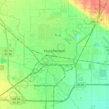
Nombre: Mapa topográfico Hutchinson, altitud, relieve.
Lugar: Hutchinson, Reno County, Kansas, 67504, United States (38.00554 -97.96632 38.10895 -97.84613)
Altitud media: 471 m
Altitud mínima: 455 m
Altitud máxima: 502 m
Hutchinson is located at 38°3′39″N 97°55′47″W / 38.06083°N 97.92972°W / 38.06083; -97.92972 (38.0608445, -97.9297743) at an elevation of 1,535 feet (468 m). Located in south-central Kansas at the intersection of U.S. Route 50 and Kansas Highway 96 (K-96), Hutchinson is 39 miles (63 km) northwest of Wichita, 200 mi (320 km) west-southwest of Kansas City, and 395 miles (636 km) east-southeast of Denver.
Otros mapas topográficos
Haga clic en un mapa para ver su topografía, su altitud y su relieve.
Partridge
United States > Kansas > Reno County
Partridge, Reno County, Kansas, United States
Altitud media: 492 m
Hutchinson
United States > Kansas > Reno County > Hutchinson
Hutchinson, Reno County, Kansas, 67504, United States
Altitud media: 474 m
Buhler
United States > Kansas > Reno County
Buhler, Reno County, Kansas, United States
Altitud media: 452 m