
Mapa topográfico Fishers Island
Mapa interactivo
Haga clic en el mapa para ver la altitud.
Acerca de este mapa
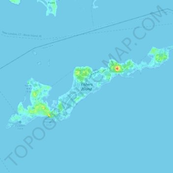
Nombre: Mapa topográfico Fishers Island, altitud, relieve.
Lugar: Fishers Island, Suffolk County, New York, United States (41.24944 -72.03866 41.29245 -71.92181)
Altitud media: 1 m
Altitud mínima: -2 m
Altitud máxima: 39 m
Otros mapas topográficos
Haga clic en un mapa para ver su topografía, su altitud y su relieve.
Battery Barlow (historical)
United States > New York > Suffolk County > Fishers Island > Fishers Island
Battery Barlow (historical), Fox Lane, Fishers Island, Suffolk County, New York, 06390, United States
Altitud media: 1 m