
Mapa topográfico Monteagle
Mapa interactivo
Haga clic en el mapa para ver la altitud.
Acerca de este mapa
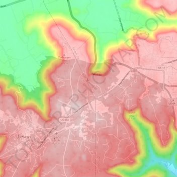
Nombre: Mapa topográfico Monteagle, altitud, relieve.
Lugar: Monteagle, Franklin County, Tennessee, 37356, United States (35.19690 -85.90270 35.26214 -85.78295)
Altitud media: 487 m
Altitud mínima: 232 m
Altitud máxima: 621 m
The town straddles a narrow stretch of the Cumberland Plateau known colloquially as "Monteagle Mountain".[15] This stretch of the plateau is approximately 2 miles (3 km) wide, with steep drop-offs to the northwest and southeast. Monteagle lies at an elevation of just under 2,000 feet (610 m) above sea level.[5] By comparison, two nearby cities, Cowan (to the northwest) and South Pittsburg (to the southeast), lie at elevations of less than 1,000 feet (300 m) above sea level.[16][17]
Otros mapas topográficos
Haga clic en un mapa para ver su topografía, su altitud y su relieve.
Saint Andrews
United States > Tennessee > Franklin County > Sewanee
Saint Andrews, Sewanee, Franklin County, Middle Tennessee, Tennessee, 37383, United States
Altitud media: 566 m
Winchester
United States > Tennessee > Franklin County
Winchester, Franklin County, Tennessee, United States
Altitud media: 293 m