
Mapa topográfico Lake Chelan
Mapa interactivo
Haga clic en el mapa para ver la altitud.
Lake Chelan
Lake Chelan (/ʃəˈlæn/ shə-LAN) is a narrow, 50.5 mi (81.3 km) long lake in Chelan County, north-central Washington state, U.S. It is an overdeepened lake and resembles a fjord, with an average width of 1.3 mi (2.1 km). Near its upper end, the lake surface lies more than 6,600 ft (2,000 m) below peaks less than 3 mi (4.8 km) away. Before 1927, Lake Chelan was the largest natural lake in the state in terms of both surface area and water volume. Upon the completion of Lake Chelan Dam in 1927, the elevation of the lake was increased by 21 ft (6.4 m) to its present maximum-capacity elevation of 1,100 ft (340 m).
Acerca de este mapa
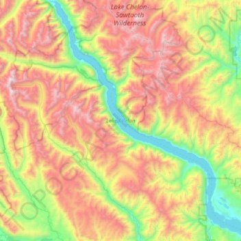
Nombre: Mapa topográfico Lake Chelan, altitud, relieve.
Altitud media: 1,358 m
Altitud mínima: 323 m
Altitud máxima: 2,796 m
Otros mapas topográficos
Haga clic en un mapa para ver su topografía, su altitud y su relieve.